
I had the good fortune to meet Michael Davias, the author of the Perigee Zero website, at the AGU Fall meeting last December. Mike has taken the Bay phenomena on-line better than anyone — including me. He has also been fearless in his (well considered) speculation. I have long intended to get Perigee Zero properly linked and posted on the Tusk.
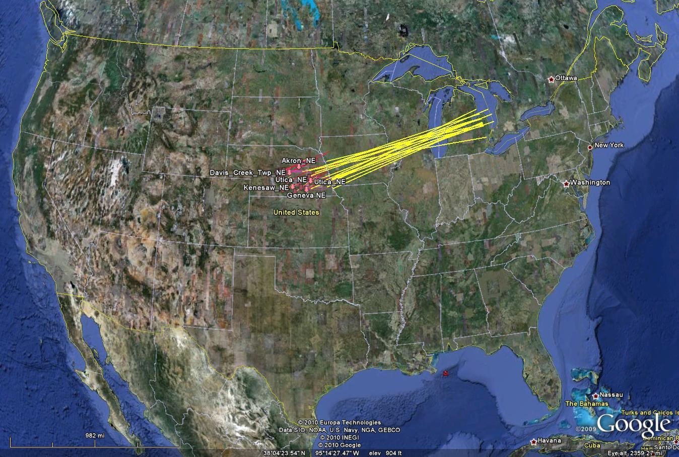
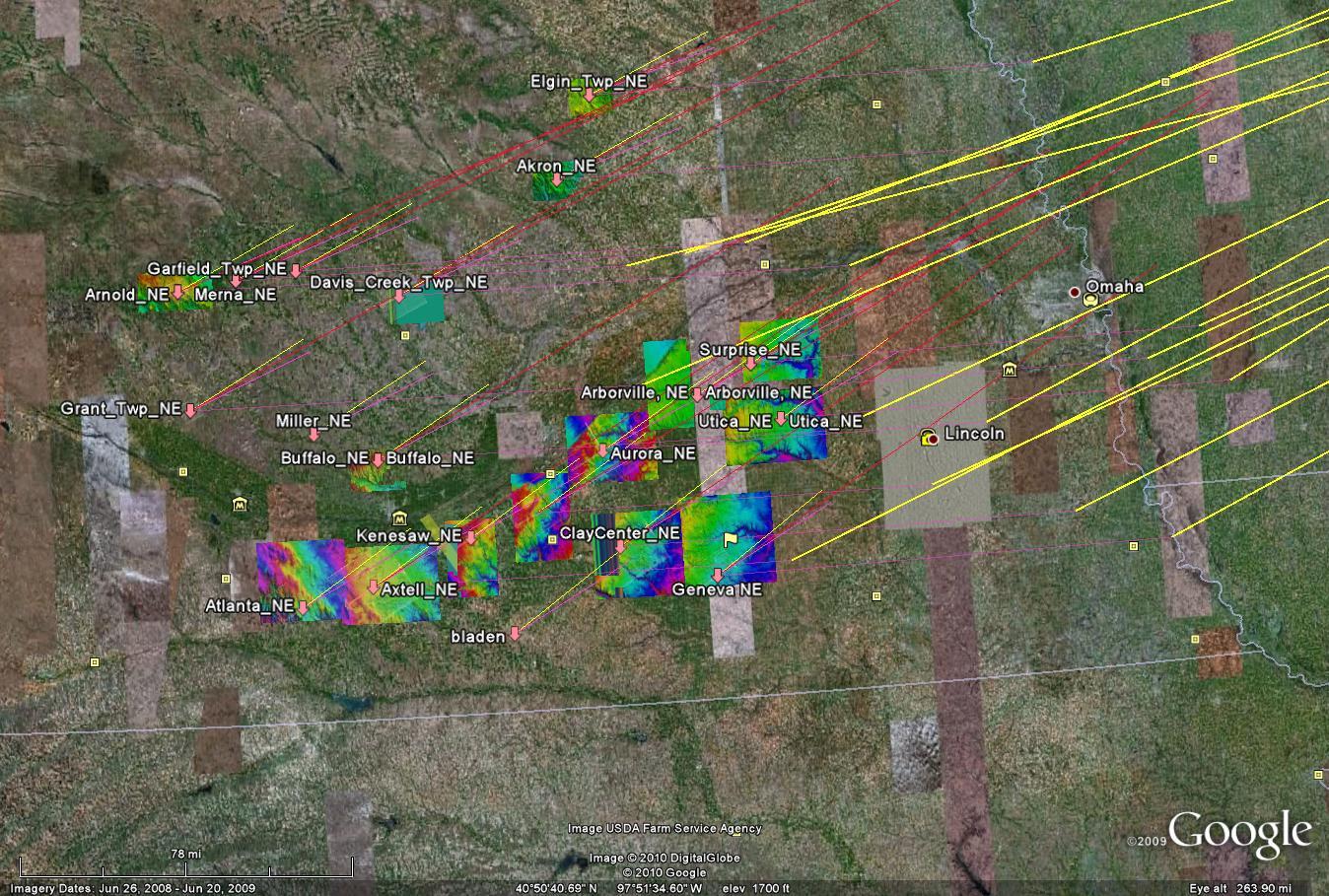
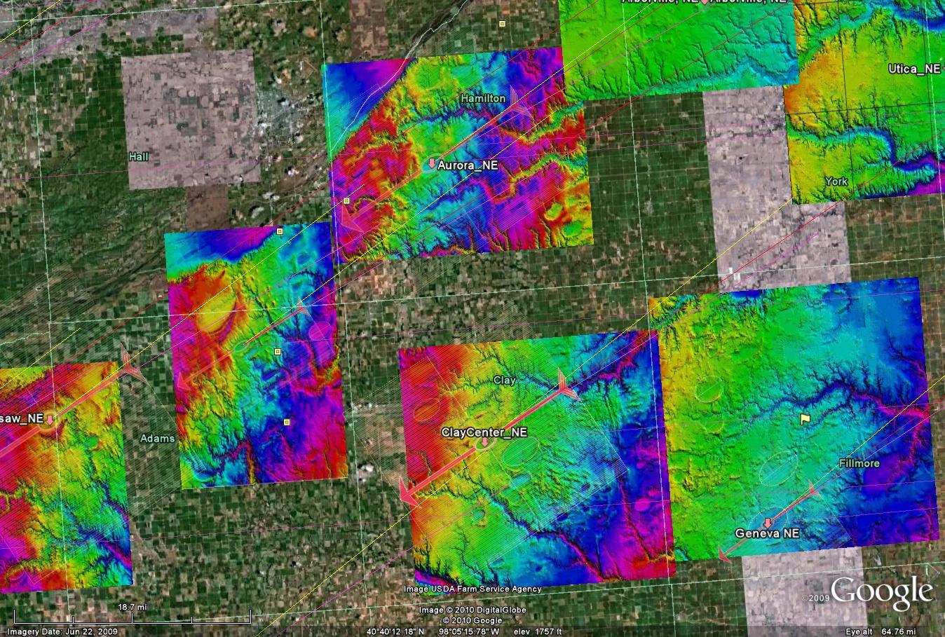
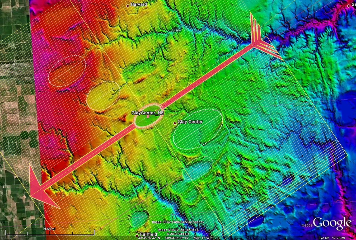
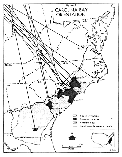
I am particularly interested in posting Mike’s careful documentary images of Carolina Bays in the the Midwest [do not miss his comprehensive page on CarolinaCornhusker bays here]. These features, entirely true to their southern neighbors in orientation and dimension, are also entirely absent from the long debate over the origin of Carolina Bays. In fact, the scholarship on the distribution and orientation of these features seems to have died long ago. Incredibly, it is not unusual to this day to see Dr Prouty of UNC’s old ink drawing from the 1950’s used to demonstrate their range (, or the also moldy Eyton and Parkhurst orientation map of 1974. SEE BELOW
By using LiDAR, Allen West, me and, most expertly, Mike Davias, have shown the old conception of a Carolina Bay to be far more narrow than nature actually presents. Any theory of their origin must account for thier extraordinary regularity across half a continent.
I will put some more Perigee Zero stuff up later. But, to get you started, below are grabs from a superb Google Earth KMZ file from Perigee Zero:
CLICK HERE TO EXAMINE THESE FEATURES
![]()

Old ink Prouty map from the 50’s
 Eyton and Parkhurst moldy map from 1975
It seems to be these scientists from the earlier times (William Prouty), and others before him, were far more open minded than the majority of scientists in the present day. This is despite earlier researchers not having near the investigative tools that we have today.
Yes, in a funny kind of turn around, they went from willing to see the truth when they didn’t have the tools to dig it up, to having the tools, and being closed minded to the truth they revealed.
These Midwest bays are very interesting. I’m still struggling with the physics of the PZ presupposition of an orbiting comet eventually impacting at shallow angle (~5 degrees). Assuming its kinetic energy transfer is perfect, no more than 9% will be directed downward, which, to be sure would still be a significant amount. (Of course, if you posit a large enough impactor, then anything is possible, I suppose.)
I’m still trying to get my head around how water ice that has been blasted into steam mixes with underlying soil and rock, in a completely chaotic event, then the mixture forms flying blobs of wallboard-compound-like consistency that remain intact over a 900 km trajectory moving at 4000+/- km/h through the air to create quite uniform elliptical divots only in the unconsolidated sediments of the coastal plain (and now in similar sediments in the Midwest). This is truly incredible to me. I think I have a physicist on my faculty where I work who may want to jump in on this. Perhaps we can work up some credible experiments.
Does anyone know what the underlying rock strata are in Nebraska?
I’m not sure if anyone has looked into this, but if you place a NC geology map under the Carolina bay kmz compiled by Dave Kimbel, you will note a fault line running more-or-less parallel to the coast well inland at the south end of the pattern, near the SC border. Interestingly, there are no bays inland of this fault line, while they are quite dense just to the coastal side of the fault. Now, why would comet splatter display a preferential distribution in relation to a geological fault? Just curious. (See the map at http://tin.er.usgs.gov/geology/state/state.php?state=NC)
Terry
Good points, Terry.
Unless the divots can be shown to be of a different soil than their surroundings, then we have to come back to other fragments diverted tangentially by the force of larger impacts as a possible causative agents.
Hi Terry,
The Bays are probabably not caused by the direct impact of comet ‘splatter’, or fragments.
I think the bays make more sense if we think of them as the scars of massive chunks of the blasted Laurentide Ice sheet thrown outwards from impacts into the LIS. This gives a plausible explanation of why no bolide fragments have ever been found in one of the Bays. It also explains why their long axis always points back to places on the ice. Think impactites of ice.
And there is no need to look for a crater in the Canadian shield. Because even if the ICE impacts made craters in the LIS much bigger, and deeper, than Barringer crater in Arizona, The ice sheet was thick enough that those craters would have disappeared completely when the remaining ice melted. Leaving behind only inigmatic depressions in the ice free surface we see today.
This was a vastly different kind of catastrophe. I’m sure it will eventually be possible to work out exactly what form the planetary scarring took. But in the final analysis, I don’t think those scars will be found to be the craters most folks have come to assume we should expect.
The signatures of this event should be the marks of seemingly impossible heat, and pressure, in the presence of a lot of water. Not ballistic/kinetic shock effects. Some form of migmatite that can be shown to have formed right out on the surface would be a pretty good smoking gun.
Or perhaps ‘volcanogenic’, or ‘volcaniclastic’ rocks that aren’t old enough. There has been no volcanic activity in the Canadian shield in more than 2.5 billion years. That’s really deep time; more than half the age of the Earth. So any formation of melted rock, or ‘tuff’ that returns an age since melt that’s measured in millions of years, or less, is also a red flag.
Landforms similar to the Carolina Bays can also be seen in the north coastal planes of Alaska. These “bays” are also oriented in relation to the coastline which would inticate to me that the Bays origin is water related. The elongated forms of these elipsiods might inicate a greater water velocity than those in the Carolina coastal planes. Check these landforms in Google Earth @ 70-59-30 N, 156-53-48 W.
Dennis,
OK, just for the moment let’s assume the divots were made by one of the phases of water from the LIS, rather than rock. Which phase could account for the uniformly-shaped, very smooth-edged, sub-elliptical, shallow depressions? If impactors were chunks of intact ice, then these features would look more like impact craters, especially from the larger chunks. Assuming that they had enough energy to vaporize on impact, the “craters” would look more like the ray patterns on the moon, I would think. If they were ice chunks that transitioned to water during impact of the comet or at any time during their trajectories, then the high velocity of the atmospheric transit would have splattered the globs of water into a zillion droplets, rather than discrete water-balloon-like impactors. And of course, steam explosions just above the surface, for so many different sized chunks would have required some sort of proximity fuze to produce such uniformly-shaped divots.
The PZ demonstration of wallboard compound globs suggest the kind of impacts that might have produced CBs, but there isn’t any credible explanation how such materials could form, then survive a 8-900 km, high velocity atmospheric transit.
Just thinking out loud. You guys have obviously put a lot more time into this topic. Has anyone thought of a subterranean source, like mudpots or something? I realize this goes completely against an old-earth paradigm, but this is what scientific revolutions are all about. Data that doesn’t fit. Thomas Kuhn would love this.
Forget subterrainean sources. And the material that impacted to create the bays didn’t survive the trip. The steam explosions were only in the LIS.(The pristine hydrothermal burn marks at the points of origin are not hard to find) That’s what launced them. I don’t think the ballistic ice, and slush, fragments had as much velocity as you seem to attribute to them. They would not have been solid chunks of ice. By the time they hit, they would have been semi-melted blobs of water, and slush. So the CB impactors didn’t hit; they splashed.
As for that ‘Old Earth’ paradigm, try a subtle shift in emphasis. Think old Earth-paradigm. The Earth’s old all right. Very, very old. It’s just that some of the surface terrains of North America that we’ve always assumed to be ancient, are brand spankin’ new. All of the Earth sciences are founded on the unquestioned, 19th century assumptions of uniform,gradual change, and the principle idea that ‘The Present is the key to understanding the past’. And yet, the simple empirical fact, is that it isn’t. In fact, there has been nothing in the short period of time referred to as ‘written history’ that gives us any clue at all as to the level of catastrophic, mass extinction, violence which has happened in geologically recent, human times.
We find ourselves at the cusp of a major paradigm shift in the Earth sciences that will change them all down to their very foundations. And that paradigm shift will be every bit as far reaching as the realization that the world isn’t flat.
The CB’s cannot be explained by any phenomena in the standard, assumptive, uniformitarian landform theory toolkit. You have to look at them from the other side of the paradigm shift. Or they’ll drive you crazy.
Dennis, on another subject dear to your heart.
Take a look at this passage from the paper: The Genesis and Collapse of Third Millennium North Mesopotamian Civilization (link here: http://www.scribd.com/doc/31277875/Mesopotamian-Collapse:
The excellent preservation
of layers of windblown dust in these specific
locations can be explained by the reduced
effects of post-depositional disturbance on
archaeological sites in comparison to surface
soils on the flood plain. Some coarse
sand layers of aeolian origin consist of
silt-sized volcanic glass particles and*************potassium
feldspar phenocrysts, clearly volcanic
in origin,***************embedded in a pale yellow, isotropic,
fine-ground mass. The close morphological
resemblance of these particles
with the features marking Tell Leilan occupation
hiatus phase 1 and the overall characteristics
of the stratigraphic unit suggest
that they relate to the same arid event.
Are the “pottasium feldspar phenocrysts, clearly of volcanic origin” of interest or help to you in this context? Seems the ignigbrites have the same stuff in them. But of course the ignigbrites are not in a recent archeological context….
P.S. You should google Peter Schultz’s (Brown U.) hyper velocity, oblique angle, ice sheet impact experiments at NASA’s Vertical Gun Range before you say with certainty that there isn’t a plausible model for lofting iceberg sized chunks of ice into a subsonic, ballistic arching, trajectory.
George asked:
“Are the “pottasium feldspar phenocrysts, clearly of volcanic origin” of interest or help to you in this context? Seems the ignimbrites’ have the same stuff in them. But of course the ignimbrites’ are not in a recent archeological context….”
I couldn’t read that paper. Sometimes Scribed is a little fuzzy. But your question seems to indicate that I need to clarify how I’m using the word “ignimbrite”
Keep in mind that impact melt is often mistaken for ignimbrite, or volcanic tuff. And to clarify what I am describing I have only used ‘ignimbrite’ for wont of a better word. There is a huge, and dramatic, difference between the processes that form, and emplace the melt I am describing, and anything even remotely volcanogenic.
If we break ‘ignimbrite’ down we get Ig-Nim-Brite, and translated literally to English. We get ‘fire-cloud-rock’ In the purest sense of the word that definition holds up. But I’m stuck with using old terminology that confuses what I want to say. I’ll explain.
In an explosive volcanic eruptive event, ignimbrites are produced as the rock erupts explosively from below the surface. The rock, as well as the heat, and pressure, it brings with it, share the same subterranean source. The pressure begins to dissipate very quickly with any distance from the vent. And It does not provide a motive force once the volcanic materials are on the ground. Once an ash cloud has collapsed, and the material falls to Earth, the only motive forces left to provide material movement are gravity, and momentum. Any welding of the ‘Tuff’ is by heat remaining in the rock.
‘Impact melt’ is another form of ‘fire cloud rock’. Which is why it is sometimes mistaken for volcanic tuff. But we see a dramatic difference in its process of formation. Because the source of the rock is the surface itself, mixed with what’s left of the bolide. The heat, and pressure is produced instantaneously at the surface, and at the moment of impact. After the initial impact explosion there is no continued production of the heat source. And almost all material movement is provided by momentum.
But the melt I am describing was formed, and emplaced in a third, and vastly different kind of process from anything described before. This is a different kind of impact event from anything that has been described before. In it, the comet is heavily fragmented before it even gets close to the Earth. It hits as clusters, and streams, of high velocity, explosive particles, and fragments, that explode very high in the atmosphere. They aren’t point explosions either. The momentum is retained; even though all of the kinetic energy is translated into heat. And it continues downwards in moveing explosions, as super heated, supersonic, down-blasts like Tunguska 1908. But the Tunguska object arrived alone. I am describing a fairly constant stream of thousands of fragments like that. Accompanied by clouds of particles down to the size of dust grains. It hit at a low angle of about thirty degrees. And at a velocity of about 30 kilometers per second.
Only the very first fragments fell into cold atmosphere. The rest fell into already superheated impact plasma, and just cranked up the heat and pressure. The down blasts are almost continuous until the last of the fragments falls, or the Earth finally moves out of the orbital path of the comet. In the case of the Taurid progenitor, the process probably lasted a little more than an hour.
The resulting heat, and pressure, didn’t make craters. It ablated the surface. And accumulations of that geo-ablative blast melt are the stuff I have been describing as non-volcanic ignimbrite. In this form of ignimbrite formation, and emplacement, the heat, and pressure is almost continuous. So it continues to ablate the surface, creating more aerosol blast melt. And acting as a motive force to drive the the motions of the melt, like the waves of debris laden froth on a storm tossed beach, until the last of the impact down-blast explosions. The resulting accumulations of breccias, and geo-ablative, aerosol, blast melt, are a form of ‘Fire Cloud Rock’ in the purest sense of the word.
The trouble for forensic geologists who’re trying to unravel this mess, is that if you do that to a volcanically active region, and that means most of Mexico, and the American southwest, then any volcanic materials already on the ground, or erupted during the impacts, are going to ‘contaminate’ the melt, so to speak. So chemistry doesn’t get to have the final word here. I think that speaks to your question.
But if you want to understand an explosive event after the fact, you should first look to the motions of the blast effected materials.
So It all goes to fluid mechanics, and studying how they moved, and flowed, during emplacement. In the model I am proposing, there are three different modes of ignimbrite formation, and emplacement, not just two. And thanks to dramatically different modes of formation, motive force, and emplacement. each, have distinct, and easily recognizable patterns of movement, and flow. When I speak of ignimbrites, I am mean to say specifically: Welded accumulations of geo-ablative breccias, and aerosol blast melt, produced in a multiple airburst, thermal atmospheric, geo-ablative impact event.
Dennis, a quick note before I re-read your great post. Scribd works if used correctly. Take a moment and look down at the bottom of the pane and click “full screen,” it looks like a little window frame. Given your obvious skill with Google Earth I am surprised Scribd is a challenge:)You are not the first to note the difficulty, however. You may need to put it in HTML mode NOT flash.
I want to know what you think of that paper. and the stuff they find. Then I have some other questions.
Thanks so much for you and the other guys attention to this site.
Regards,
GAH
I still can’t get that page to load properly. There is something wrong with the script on that page. Because 3 different computers and 2 different ISP’s lock up on it.
But I do have a comment based on that one line “pottasium feldspar phenocrysts, clearly of volcanic origin”
They say ‘clearly of volcanic origin’ when they see materials like that because they know that such materials are the signature of great heat, and pressure. The assumption there, comes from the belief that such conditions can only have a subterrainian source. But the error in that assumption is revealed we come back to the ND’s. Because the atmospheric conditions of heat, and pressure required for their formation, exceed those required to produce pottasium feldspar phenocrysts. So we can say that underground is not the only place it gets that hot.
The next question I would ask is: Can you show me the vent? Or is it one of the theoretical kind that remains to be discovered?
George,I’m completely stuck. Do you have a copy of that paper in a different format? Every time I try to load it from scribed, the page locks up at about page 2. I get to read just enough to get interested. And to know I need to read the whole thing. And then the page stops responding.
~Dennis
Ok, Now that I’ve read the paper I can get a little better Idea what you’re asking. And while that is a different archeological context, the terrains there are very recognizable.
There are at present four places that I would call, without a moments hesitation, a geo-ablative terrain. The closest to me are the pristine blast effected materials near my home here in central California. The other, just as pristine, and probably formed in the same event, is central Mexico. And the ignimbrites of the Chihuahuan Desert. The third is central Australia. In the area around Alice Springs. It’s a little bit more weathered than the Geo-ablative terrains in North America. But the patterns of movement in the blast effected meterials are still legible. And the forth region with recognizable geo-ablative terrains in very good condition is Mesopotamia, and the Middle East.
If I were them, and without a possitive ID of a local vent to blame for them. I would not be so quick to assume volcanic origin for the disaster those materials describe. Do you know if anyone else has considered the possibility that the tephra might not be volcanogenic?
I was wondering if the physics would change if the said impact event occurred 11 to 12 thousand years ago when North America was covered in possibly 3 miles of ice?
Sean,
Yes, the ice would change everything. And it’s pretty much the scenario we’re considering here. The ice sheet impact experiments Pete Schultz did at the HVGR at NASA Ames Research center indicated that in a low angle impact into a low impedance layer such as an ice sheet, the impactor could be up to the thickness of the ice cover in diameter, and still leave no recognizable crater or shock metamorphic effects in the sub-ice surface. Just some “enigmatic depressions, and disturbances in the Canadian Shield”.
So in the great lakes region it just may come down to finding debris of the impactor/s and ET chemistry in some of those enigmatic depressions Dr Schultz predicted. And it is a fair bet that those locations, when found, probably won’t have any resemblance at all to a normal crater or impact structure.
Dennis –
Good points.
I would point out that other observations can be made from Schultz’s ice impact experiments. Note that the ice fractured into large slabs and those get pushed around by the force of the impact. The question thus would arise – What evidence can be found that such huge ice slabs moved?
I don’t ask this lightly. Much of eastern Illinois Wisonsinan moraines show what might be evidence of those slabs moving instead of the currently accepted “normal” ice sheet advance and then retreat. All the evidence really shows is that gravels were laid there by some agent. The assumption that they are moraines is not the only possible explanation. It IS, however, the only gradualist explanation – thus, that is the explanation that is accepted.
Hello to All
Although the hypothesis of a Glacier Ice Impact is plausible for Carolina Bays, I believe there is another way of explaining the direction of the structures from the Earth’s rotation and Local Time of impacts.
https://sites.google.com/site/cosmopier/impact-craters/palaeolagoon-geometry
A common radial point could be an illusion to explain the direction of Carolina Bays, just like when we observe the meteor radiant, although parallel, they seem to come from a radial point.
regards
pierson
Steve; I grew up in tyhe Palos area of N.E. Illinois. there is a vast forest Preserve system that encompases a tremendous amount of Morraineal structures. The army corps of engineers built a ship canal through the bottom of the palos valley area from Lake Michigan to the Illinois river passing through the glacial drain by Lemont. The morraines are basically clays with small amounts of gravels in them. The valley floor has much more gravel and it is with footage of the bed rock. On the top side of the morraines the ground becomes rolling “flat” ground for miles on both sides of the valley. I would think that the leading edge of the glacier would be lower in height than the middle sections and be more prone to moving in large slabs then staying in place and melting once motion has stopped. Much like a car going through a frozen puddle, the ice gets broken and thrown to the side stopping only when all energies have been expended.
Jim –
I lived in the Chicago area , mostly NW suburbs, for 38 years, but know little about the Palos area. Palos might as well have been Kentucky. But in the NW burbs we had plenty of moraine features, too. But we had DEEP gravels up in McHenry County – lots of gravel pits, ones that visually look to be 100-200 feet deep easily.
It appears that you are addressing my suggestion that ice slabs might have been moved somewhat in toto. I would agree that the leasing edge of a glacier or ice sheet would be less high than the interior. That is the standard understanding of ice sheets.
If the ice slabs moved as a unit, I am enough aware of the friability of ice and would expect them to begin to move as a unit but then to fracture into smaller slabs as they encountered resistence from the ground features they are traveling over. I would think that by the time they moved any distance it would be far different than Schultz’s mini-experiment. In other words, I don’t think Schultz’s experiment is necessarily scalable upward to large events, not without some complications coming into it.
As to the car analogy – thinking like an engineer, I would think the analogy doesn’t hold true. The ice being broken by car tires is pushed to the side because of the narrowness of the tires. An ice slab 50 or 100 more 300 miles wide would do mostly pushing forward, not to the side. A narrow slab – like modern glaciers – would tend to push ice aside like lateral moraines that we see. The EDGES of ice slabs would push material to the side, yes – but with a wide slab the edge regions are only a small percentage of the slab width. The leading edge would be doing most of the pushing.
Correct me if I am wrong. I am not invested in this – just discussing it. I appreciate the dialogue.
Ice sheets
Steve; I would guess that the direction of motion of the ice sheet would be dependent on the angle of the impactor. If the impact is straight down then the fracturing psi’s should go fairly even in all directions. Then as the angle of impact changes the force of impact causing the ice to fracture more in front of the impact then radiating outwards. Also if the impact was on a lobe of the ice sheet i believe the lobe would be more prone to fracture and movement than the larger ice sheet. The Palos area is S.W. of Chicago. The area looks more like an out flow valley that was filled with ice after the fact. Feasible?
Jim, one major compenent of an ice sheet impact that shouldn’t be underestimated would a very powerful hydrothermal explosion at the point of impact that would be independent of the directionality, or momentum of the impactor.
Dennis; Would the hydrothermal and impactite explosions be similtaneous or would there be an infantesmal delay between the two? Also would an airburst be stricktly hydrothermal or would there still be somewhat of a solid piece to hit the earth?
Jim; You can easily run a simulation yourself; Heat a coin or small metal object red hot, then drop it into a pot of water.
There would actually be two impactite events and a hydrothermal event, plus some atmospheric event. This scenario depends on the impactor being massive enough to survive the atmospherict (airburst). After that it would hit the ice, which because of the velocity and energy involved would behave much more solid than we percive it with our senses. However, the energy expended would most probably melt the ice all the way to the surface for a large impact object.
Perhaps some techie here could do up a cartoon to depict what I’m saying: With decreasing levels of energy fron the airburst, through the ice impact, hydrothermal event, and eventual settling on the earth’s surface. Lots of possible variables.
This is an interesting thread, and may explain conditions I’ve seen in on Eastern Vancouver Island where a large area of sandstone is fractured like windshield glass hit by a stone.
An overlaying icesheet may have absorbed much of the impact energy and spread it horizontally while ocilating like a drum skin. Just a thought. Looking forward to comments.
Steve; I was looking over a map of the wisconsin glacier end morraines and I noticed that the last moraine before the end of the ice age was over most of the Chicago area and it was 3-4x thicker than any previous morraine. This might bode well for your idea of major fracture of the ice moving quickly and independently of the main ice sheet. It would appear that the ice instead of moving slowly and overiding some of the the ground, it goes just plowed into the earth and pushed up a much larger end morraine.
Jim –
Thanks. It seems reasonable and in line with the other aspects of Schultz’s experiment. That doesn’t by itself make it true, but it does make it a decent direction for further experiment.
I am bothered by the assertion that the ice in eastern IL is automatically considered another slow grinding of a glacier.
Steve; That same paper by Mickleson I believe also mentions that The lake Michigan and Saginaw lobes were moving much faster during both advance and retreat. Saginaw was the fastest but when it retreated it did not readvance as did the others.(Ice sheet impact destruction anyone?)Another idea to throw out. There was more than likely a glacial lake at the end of the Michigan lobe as it retreated, The main ice sheet is firmly planted on the floor of the lake. If bergs were broken off the main sheet by impact they could conceiveably float into and rebound from the end moraines multiple times creating small morraines each time.
Steve; Just to let you know, I finally got that #$%@876^519* computer to release the pics I took of that holey Dolomite I also took a closeup shot of the exterior surface to show the pitting better. Sorry it’s taken so long.
Hi everybody,
I’m bringing up this older post because yesterday, on a flight from DC to Salt Lake City, i had the opportunity to fly over the length of Nebraska. I was lucky enough to have very good weather with clear skys.
The “bays” were clearly visible, and due to the time of year, I’m thinking the corn is mostly harvested and or the wheat is close as most of the state was very brown and the terracing in the hilly western part of the state was clearly visible, the overall topography was well illustrated.
The bays cut across and overlay relatively recent, geologically speaking, features. With the overall browness of the landscape, the hydrology of the region was also well defined as the flow patterns of surface water, green ravines and streambeds leading to the rivers was very well defined.
It was like flying over a living topo map.
The bays in the eastern and central part of the state are tear drop in shape with out fail have a general north east to south west direction, with the narrow end to the ne. The raised rims were taller in the sw “drop” end .
They lie in the dead flat plains, on the low rises separating creek and river drainages and both the windward and leeward sides of low hills. It can be seen in some places they cut across and rerouted some smaller creeks.
By comparing the shadow lengths of the bay rims with that of human structures near by, such as farm houses and silos, of which there are plenty, I’m thinking the rims have a height of 20’ish for the smaller bays, who’s length is maybe up a hundred yards. The larger bays, and there are some big ones, rim heights are maybe up to a fifty feet or more and have lengths of up to a 1/4 mile or more. Overall their interior depths are 1/4 to 1/3 deeper than the exterior Rin heights. In one place the cut across the bluffs of what I would say is a large glacial flood outflow channel. It was very wide with bluffs maybe 100′ ?tall. At it’s widest I’d say it was more than five miles but averages about 2 miles. It clearly cuts across pre existing topography, and has a small river on each border with a larger one meandering within in it’s channel. In some places at the outwash end, the alluvial deposits are still visible as cultivation works around them.
There were several bays within this flow feature, so they were laid down after this major outflow event.
The most interesting thing is that there is a change in direction in the western part of the state where there is an abrupt rise in elevation of several hundred feet and the terrain becomes a maze of ravines and creek cuts.
The bays abrubtly changed direction from ne to sw, to nnw to sse. There are also older, more weathered circular features whose rims are all but gone but are still visible.
I know this is hardly scientific hard evidence, but good observation is the begining of most scientific enquiry.
And I obsevered the crap out of them with my freakishly good distance vision, I was able to see someone riding their dirt bike on a trail while flying over at 29k ‘.
Also Google earth does not show most of the bays, as thier images are false colored composites. Where several bays were clearly visible from the air, all GE showed was green irrigation circles.
I hope this is of some use.
“Google earth does not show most of the bays, as thier images are false colored composites. Where several bays were clearly visible from the air, all GE showed was green irrigation circles.”
they used to be clear..
because I am not seeing the very clear ones on north western Africa and those ran more north and south and they were HUGE ones. those bays ran more north and south. and therer was some clearly in north eastern south america .. I can’t find those now either , it is clearly scrubbed , .. if you check the un-scrubed areas sometimes you can still find the smaller ones around the cities that are not scrubbed
but stuff is all scrubbed and in fake colors .. makes you wonder what someone is trying to cover up hum? because it obviously scrubbed and colored in like a three year old with a crayon.
Cosmic,
I think GE is just taking shortcuts, and here is my reasoning. The area has been laid out very very regularly. For the most part roads and property boundaries run due e/w or n/s. I’d put the grid at one mile a side and further subdivisions at 1/2 and 1/4 mile.
The average farm was 1/2 of the one by square.
One half of that was the average planted plot.
A small percentage of the plots were irrigated by irrigators, a 1/8 mile long sprinkler pipe on wheels that swings around a central pivot. They leave a very distinctive footprint, and in places where they clearly aren’t in use, GE shows them.
It’s a software thing they are just “draping” an image over a very roughly modeled 3d surface. The place is so flat that I would bet that it isn’t within their resolution, which if you use the USGS standard which is an 80′ contour, ans they wouldn’t show up at all.
And since they show areas covered with irrigators, where they clearly aren’t in use, I’d say the soft ware is filling in with a standardized image.
Cevin –
Cool stuff. Thanks for the report on them.
Comments/thoughts:
– The rims seem quite high, compared to most of the eastern CBs.
– The shift to the NNW>SSE is interesting and counter to what I’ve seen on Michael Davias’ LIDAR. That direction is almost perpendicular to the ones in the other part of the state. So I’d like to ask if you maybe meant NNE-SSW? Just to be clear.
– On GE, have you looked at any of the historical images?
On the historical window, there are date spans shown for each image, showing the sequence of the images. The older images are SHOWN when you click the time span. Some go back to the 1990s, and a few I think I’ve seen go back to the 1980s.
Tuskers; I was just reading the Carolina Bays postings and was looking at the Goggle Earth images. As I looked at the continental Us Image I was struck again by the crater like impression covering the 4 corners area. This is an extremely large dia image. and more than likely very old as there are no evident signs of ejecta waves to the sides, But the western Neb Bays do line up reasonably well with that “crater”. There is also a string of rough circular patterns (3) extending south along the Rio Grande from Elpaso. There are also (3)? north of the 4 corners area from just outside of Yellowstone south through Colorado. The 4-corners location appaears to have a central uplift ridge runing NW-SE and possibly a central cone. I’ll need more time to hone in on more detail but it’s an interesting possiblity.
Steve ,
That feature in the four corners, is it in Co?,
if so it might he the La garita Caldera, but it’s oblong.
Are you aware of the huge crater field in nw Texas?
I’ve flown over it several times, and there has been no substantive work done on them, I have searched extensively and there is literally nothing.
The place is covered with thousands of craters,
and they are fairly young as they are still crisply defined.
By nnw/sse, I meant
North/ northwest more north than west and more south than east.
There werent many in that directional grouping, less than a dozen are visible to me
The rim heights are a pure guesstimation based on a visual comparison of shadow lengths. I know it’s hardly scientific, but wasn’t planning on mapping the elevation profile of NE when I got on the plane.
The sun was at a good height though, somewhat low in the sky, the silos and farm buildings were giving good shadows with which to compare.
The dirt roads went through the smaller features but around some of the larger ones, indicating an abrupt boundary that one can’t just drive over or is to big to cut through with a grader.
For the most part cultivation went around most of the larger features, also indicating that these were not shallow rises that you could easily drive a tractor or harvester over.
Cevin; This is Jm Coyle bringing up the “crater” at 4 corners. The indentation I’m referring to is straddling 4 different states the majority of it in Arizona and New Mexico. The rebound ridge runs from Utah through the corner into New Mexico. Also in Texas you will notice 2 or three large ovid “shadows” that take up approx 1/4 of the state. Velly intresting. Off the coast of Baja California just north of the center of the pennisula there appears to be a crater feature with a rebound cone showing. Again, Velly interesting. These are all maybes at best but worth looking into.
The Saginaw crater may or may not have anything to do with the Carolina Bay ovals which I have seen go down all the way to the Bahamas. But even more than that they are also found in southern Australia, of similar value and relationship. From Toolondo all the way up past Kinchega National Park. 548 kilometers away. To Lake Bonney east of there. Between Piangil and Koropp there is a strong concentration of them. Not all of them are pointing in the exact same direction, as is the same case in the Carolina Bay ones.
CB’s are also all over North Africa and they are HUGE and Northern Brazil and smaller like our cbs …. though google is doing a kind of smear where you can see it or anything in those areas . gosh I wonder why !
Ps the third time it happens will a charm .
http://www.csmonitor.com/Science/2011/0113/New-zodiac-signs-2011-Why-astrology-is-even-sillier-than-we-thought
forget the article … look at this old plate of what the ancients called the constellations for a few clues….. that shall light up your world (as have a few times already) .
Ps after studying it some more.. I am quite sure that the Serpent portrayed in Serpent mound is from out of Ophiuchus / Serpentarius .
SO will it come out of Serpentarius / Ophiuchus again ? I don’t know but I will keep my “eyes on the side ”
and yes that quote is from a movie about big fire breathing dragons LOL .
It seems just a few months ago I learned that Ophiuchus is also I guess my new Birth constellation/ stars or whatever . and they just re- added it. lucky for me I figured out what it was and what it is about. I always thought I was a sagittarius.
but don’t worry about it.. so why worry be happy . Because as they keep telling us that the separate dragon constellation portrayed on that plate about
” the serpent bearer ” in Ophiuchus is that
it only comes around once in 36000 years! that is what it seems like .
or maybe is that is their deepest desires and more tea leaves and magic time machines talking , so they can feel like they are in control of their universe ?
Quinn Abercromby: What do we do when we are awake?
The Children: Keep both eyes on the sky.
Quinn Abercromby: What do we do when we sleep?
The Children: Keep one eye on the sky.
Quinn Abercromby: What do we do when we see them?
The Children: Dig hard, dig deep, go for shelter, and never look back.
oops I quoted it wrong for years. it just sounds like
“side” with the kids screaming it . From Reign of Fire .
ps for any christians reading this. Until you really understand that story in HIS sky his clock He created, you can’t truly get REV 12.
Deb –
I took a first look at Toolondo-Kinchega Park, and there are SOME similarities to CBs, yes. Most seem near Toolondo, and even a bot the other direction with several in the Alspey-Goroke-Karnak area. Where there are any alignments, they SEEM to be more or less N-S. Some seem reworked by wind, but as to original cause, nothing jumps out as a first guess.
I will keep those in mind myself. They may be able to shed light on things.
The ones near Piangil are numerous and when aligned at all, those too, seem to be N-S. MUCH more elongated there than near Goroke.
Lake Bonney? Didn’t see any. That is the one that is a lagoon near the shore?
Couldn’t FIND Koropp on GE or in Google. Is spelling correct?