

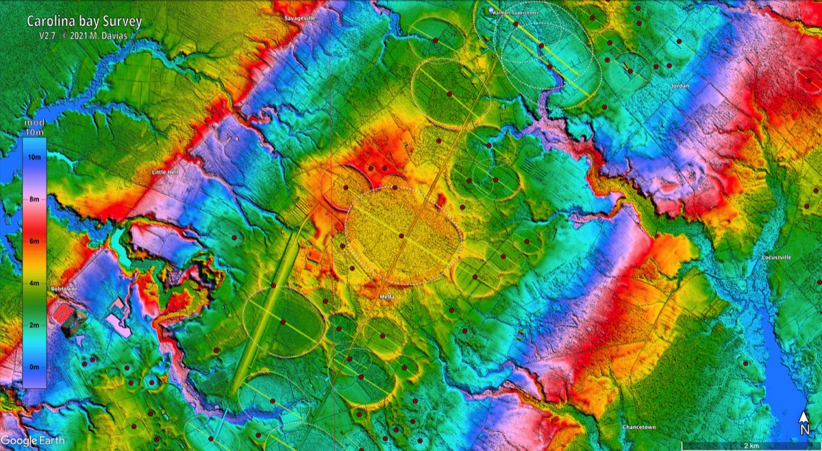

In the paper, Very high-temperature impact melt products.. there is a report (by George Howard) of using a hand auger to extract a core from the CB rim that contains a black mat section. So apparently the bay rim is younger than the black mat. This contradicts the > 130K year age for the CBs based on the age of the Wando terrace. Could not the Wando river have eroded all of the bays on the terrace? The core seems to confirm deposition of the CB sand immediately post YDB black mat formation.
Charlotte: Carolina Bays at GSA in November
15 archived comments · Oldest first
Visit the article and join the conversation →Ed, no I don't assume that at all, it's just from his coring with a hand auger in a CBay rim and hitting the YDB layer just below, that it looks that way. This is in the appendix to the PNAS "Very High-Temperature Impact Melt Products . . ," SUPPORTING INFORMATION (download PDF): www.pnas.org/lookup/suppl/ doi:10.1073/pnas.1204453109/-/DCSupplemental
Hello to all Is it possible that these structures if End-Pleistocene age, may have them been embanked immediately by great floods of melting glaciers? regards pierson
Herman: The age is certainly in question, no doubt. Please note that the Wando terrace was surfaced by the Cape Fear River when it became a flood plain after the Illinoian Glaciation terminated 135ka and the sea level rose to as much as 10m above today's. It is covered with many datable deposits which set its age as 80ka to 130ka. When the sea level again dropped going into the Wisconsin ice age, the Cape Fear abandoned the Wando Terrace (as it previously did from the Socastee, Penholoway, Waccamaw and Bear Bluff Terraces, carving deeper beneath its current flood plain position. I agree that the river may have (and likely did) "remove" bays originally resident across that expanse, but the point remains that none were created since. Certainly none 12ka. There are none on the Holocene terrace surfaces, either (which cover the expansive flood plain closer to the mouth of the river near Wilmington), but no surprise there. If the bays were created 130Ka+, we should all expect that the top 1/2 meter of sand and soil would have been remodeled, stratified with new wind-blown sediment and reworked by soil formation episodically during warmer and wetter times. The YDB debate hardly rests on the creation date of the Carolina bays! - Michael
Thank you, Michael. I hope that your note clears up Hermann's confusion. As far as the Bays' age goes, I noted that one paper cited here mentioned the presence of Clovis technology at one of them. That was prior to the HSIE. The most siognificant point about the Bays is that the sand in them contains no fossils, while they are held together by what is most likely some kind of calcium derived cement. Something strange happened; what it was, I don't know. There is so much geologicqal work to be done with known HSIE features that I'll leave the Bays for others. So far I have seen no ethnographic materials bearing on them. For that matter, have you found any other mentions in the geological materials from the area of the ca. 1,000 BCE impact mega-tsunami, or of the smaller impact mega-tsunami ca. 580 CE?
As a graduate geographer in Colorado, I became curious about the many shallow, oval depressions on otherwise relatively level western plains; aka “Buffalo Wallows.” My studies in landform evolution and employment with Shell Oil, researching deep earth gases, led me to believe the depressions were the result of soils inflated by deep earth gas emissions, initially forming low “hills.” Naturally, as hills erode, coarser debris would collect around their bases and finer particles would be swept away. Later, when the rate of gaseous emissions decreased, these eroded hills would deflate into depressions with a ring of coarse debris around their borders. Some of these depressions are a mile or more in diameter, while others are only a few acres in area. All seem to have an oval orientation in line with the direction of sands and gravels deposited by the erosion of nearby mountains. Similar depressions have been reported in Kansas and Indiana as well as the Carolinas. In addition, secondary rings have been observed inside larger rings, indicating to me that increasing gaseous emissions created another hill which also eroded and formed a secondary depression within the first, when emission rates again declined. I have seen gaseous expansions in the mud pots of Yellowstone, which resulted in depressions with raised borders, along with secondary expansions inside the first, ending with smaller depressions and raised borders inside the initial depressions. These appear much like the initial and secondary depressions which can be found across the USA and in Carolina Bays; on a larger scale. My friends with similar views have recently drilled into a number of Carolina Bays and surrounding soils. They found gas emissions within the borders to be as much as 10 times the emission rate in soils outside the borders. Now we are seeking a Carolina Bay that has yet to fully deflate, possibly appearing as a level area or low hill, with a beginning border of debris from surface erosion. If anyone knows of a possible example, please let me know. Charlie, coden33@aol.com.
Thanks, Charles!
Hi Charles, I've collected a few hundred Google Earth images of those 'Buffalo Wallows' most of the ones I've imaged are in west Texas and eastern New Mexico. And i support of your theory that they are related to gaseous emissions, the highest concentrations of them can be found in, or near large oil, and gas fields. Anyone know of any significant oil, or gas drilling/production among the CBs?
Dennis, if that is in support of gas emissions being correlated to oil or gas fields, we'd expect to find oil fields in the Carolinas. It does not really explain the overlapping bays/wallows, not that I can see. Charles mentioned "secondary expansions inside the first", but it is circular reasoning to use the term "expansions" when expansions are the supposition being considered. And what is meant by "inside the first"? Features" yes, "secondary expansions" assumes too much, as if the conclusion is already proven. Also, does it mean fully within or does it include overlaps? Charles' hypothesis does nothing to explain either the ellipticity or the alignments of the CBs, so we can put it with other 'possibles' for now. At the same time, subterranean causes do need more looking into. So far none of the wind/water/impact explanations can explain all the features, so subterranean is a viable area of inquiry. Also, Charles, any leads on the Indiana wallows? That is awfully close to the Michigan 'center' toward which Davias' work points.
Thanks Steve, I was just making the point that if the 'Buffalo Wallows' are indeed related to gas emissions, as their apparent concentrations in and around oil and gas fields might seem to imply, and if they shared the same formation mechanism as the CBs, then there should be huge oil, and gas reserves beneath areas where there are a lot of Bays. Yet to the best of my knowledge, The Carolinas are in no danger of being overrun by folks drilling for oil, or gas. I’ve been studying the ‘Buffalo Wallows’ in the southwest long enough to have collected individual images of more than a thousand of them. And frankly, I see no comparison or similarity to the form, or fractal distribution we see in the Bays. And I am extremely doubtful that they share the same formation mechanism. It should be noted though, that while there are a number of interesting theories as to the exact formation mechanism of the BWs, they remain almost as enigmatic as the Bays.
Thanks, Dennis. For the info and your other thoughts, too. As we each collect facts about enigmas, we each assign varying validities to them, and we put those together in some form of hierarchy of evidence. Using that hierarchy, we do hear possible explanations that we do get "extremely doubtful" about. I would not at all be surprised if the CBs do turn out to have a subterranean cause, though such an explanation would have some extra hoops to jump through. Davias' LIDAR work on shapes and alignments will be tough on any potential explanation except something connected to an impact. Wind, water, gaseous expansions - none of them are capable of covering any of the alignment or shape evidence. Not in my book, anyway. Not that I am the most knowledgeable, though. The wallows - is there any alignment to them at all? If so, can you point to that info?
No, there is no consistant alignment to them at all. There is also no consistent form to them like we see in the Bays. Most are round, some have double rings like a complex crater, and some in New Mexico are just too damn big to believably be simply the result of gas emmisions breaking the surface. In the work I've read, I note that to date, no one has done anything to look in detail at the mix of isotopes found in them. So I'm still woundering about the exact chemistry. I'll put together a gallery of photos of them, and post it on dropbox.com over the next few days if anyone's interested.
Buffalo Wallows are of interest to me also. We have some pretty good LiDAR of our project in Texas: http://www.restorationsystems.com/projects/katy-prairie-mitigation-bank-stream-wetland-credits-houston-texas/ The depressions are all over the place (as is gas) but I would enjoy seeing Mike Davias take shot at characterizing them over a large area in LiDAR.
OK I don't have any time for this at all. So you better highlight some BWallows and lemmie have a look.... Could be toroidal ball lightning! TH
On the subject of “Buffalo Wallows” and other strange holes in the ground, there is no shortage of places that are cryin’ for a closer look. A few might be just plain old sinkholes. Many of them look to have been modified for water management purposes. But even those show an interesting halo. Here’s a sample gallery. And it’s only the tip of the iceberg. Each image is directly from Google Earth. And the Latitude, and Longitude, is in the status bar at the bottom of the image. https://www.dropbox.com/sh/kssdajhznc77c2g/lA6ofEWbfr