


Hi George, I never liked WordPress's editor either. But Since Microsoft moved all their Windows Live 'Spaces' blogs to WordPress.com, they've also tweaked their Windows Live Writer blogging tool to be a very user friendly, and WordPress friendly, WYSIWYG invirontment. It doesn't get any easier.
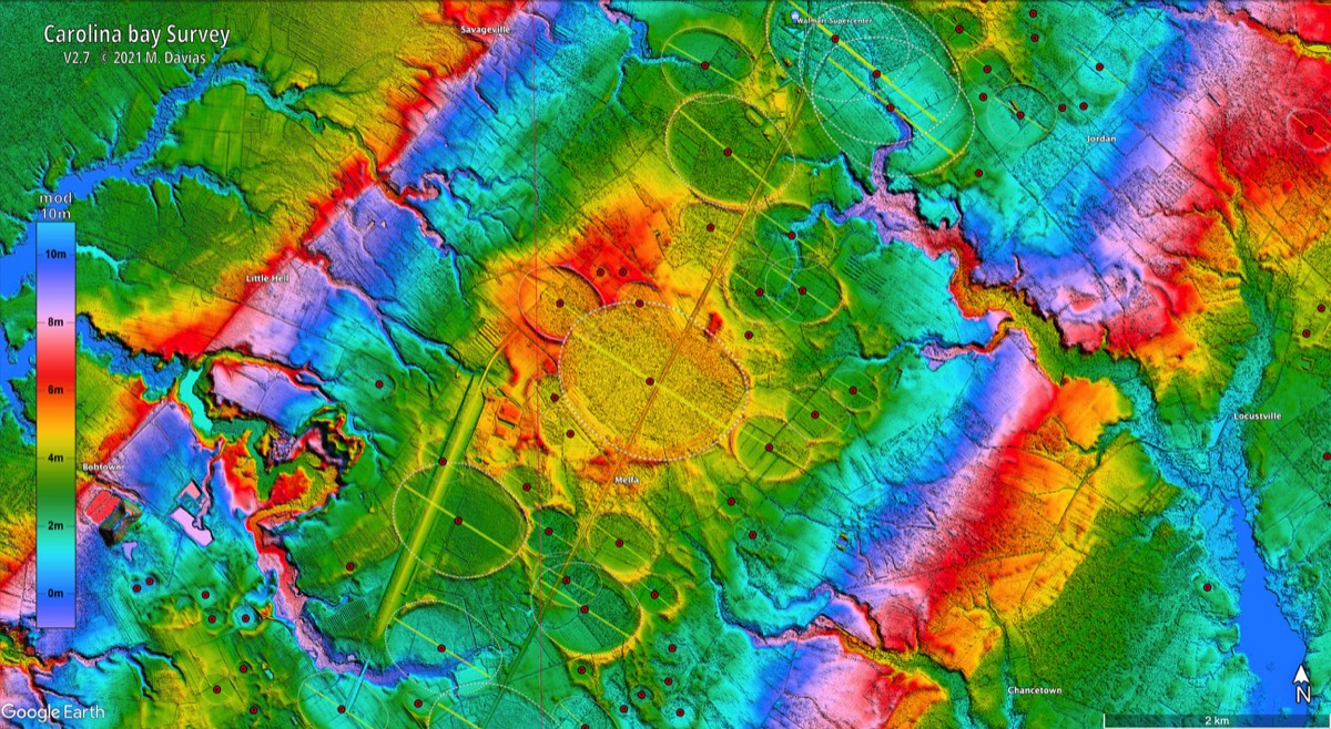
Heart of the Carolina Bays
12 archived comments · Oldest first
Visit the article and join the conversation →GEO NM paw NASA WW1.4 269 deg 1300 km high view 109.89195W_36.03306N: Rich Murray 2010.12.14 http://rmforall.blogspot.com/2010_12_01_archive.htm Tuesday, December 14, 2010 [ at end of each long page, click on Older Posts ] http://groups.yahoo.com/group/astrodeep/message/76 [you may have to Copy and Paste URLs into your browser] https://cosmictusk.com/heart-of-the-carolina-bays#comments My Xmas list: 1. coordinates in decimal degrees 2. size of field 3. elevation of each color 4. how to obtain the image 5. series of images at many altitudes 6. stereo pairs 7. site on Net where players like Rich, Barretto, and Dennis can show off all their images, with fully archived discussion allowed 8. more players to join in to comment and try their own hand at locating new features that are easily accessible on available sites near populated areas in USA and Canada 9. on the ground photos 10. links to free USGS maps and relevant research, including conventional scenarios Here's a spectacular scenario for spectacular data: GEO NM paw NASA WW1.4 269 deg 1300 km high view 109.89195W_36.03306N 1918x1128 3770 KB 2.75 MB png attachment It just leaped out like a large bear track on the dirt, late Friday evening Dec. 10, as I was impulsively following a productive research tactic for puzzling Google Maps images: click the Satellite view to remove the clutter of labels, then keep expanding the field of view, allowing subtle visual gestalts to emerge. Around midnight I confirmed the vision with Google Earth 6, and then NASA World Wind 1.4, a free 28.7 MB download java, which allows views without labels that have high resolution for altitudes above 10 km. A putative 500-mile wide "pawprint" from White Sands National Monument NNW to SE Utah -- visualize this natural result from thousands of H-bomb scale air bursts at low angles from the 35 kmps core of ice comet fragments of Bill Napier's Taurid Complex that coalesced with splashed salt water from the Gulf of Mexico and local lakes and ice to form a few linked hypercomplex hot bubbles of agitated dense plasma-gas-liquid-sludge, kilometers high, so large that it took at least minutes for them to give up their forward momentum, remaining as hot puddles over the surface for whatever time necessary to cool, releasing water and deposits, then expanding and dissipating without raising vast amount of dust high above the stratosphere (unlike the deadly dinosaur demise impact in the Yucatan seacoast 65 Ma BP). We have no choice but to allow the on the ground evidence to guide us in estimating the actual scale of the barrage of impacts. It seems prudent to start by considering the largest scales first, to establish the proper field of study -- inside the pawprint vs outside. Inside will feature subtle harmonies of patterns that the human visual system is highly evolved to discern, after recent 2 million years as an aggressive carnivore tracking game in every conceivable terrain. I started using the guiding idea of pawprints in 2009, my first year of allowing a process of fascination with Google Earth and Maps views. A pawprint might be a palm or a sole, have two, three, or many toes or lobes, usually on one side, generally the likely forward direction -- although there seem to be many examples of jets shooting forward and/or backward, as well as lofting and splashing of ejecta. Research has to consider: the huge energies resulting from chemical combustion; the degree of ionization and resulting electrical and magnetic fluid dynamics on a huge scale; the role of self-focusing currents, jets, smoke rings, great balls of fire, tornadoes, hurricanes, storm systems; pressure and aerodynamic suction (lift); rapid ablation of the surface; rapid formation in midair of many minerals; melting, glazing, cracking, excavation, and scattering of the surface; rapid deposits of flat areas, ridges, mountains; triggering of volcanoes and lava flows; formation and collapse of huge dams with ensuing vast flooding; huge dumps of sediment and large surface blocks onto the continental shelf, along with erosion of huge canyons; the removal or covering of vast areas; the resulting paucity of the fossil record; the distribution of related events globally in Holocene times; natural errors of geological interpretation and dating on a vast scale; reassessment of human evolution in Holocene times; realistic estimates of ongoing hazards. And, as an exercise for the student, there's an even larger pawprint over most of Nevada, NNE from the Sea of Cortez to Montana and Wyoming -- consider the remarkable uniformity of the basin and ridge pattern, a fingerprint if I ever saw one... Peace on Earth, and Blessings to all Men of Good and Ill Will... Rich Murray Impact melt formation by low-altitude airburst processes, evidence from small terrestrial craters and numerical modeling, H E Newsom & MBE Boslough 2008 Mar 2p abstract: Rich Murray 2010.11.17 http://rmforall.blogspot.com/2010_11_01_archive.htm Wednesday, November 17, 2010 [ at end of each long page, click on Older Posts ] http://groups.yahoo.com/group/astrodeep/message/75 [you may have to Copy and Paste URLs into your browser] GEO NV paw NASA WW1.4 200 deg 55 deg tilt 609 km high 115.99630W_36.55129N.png 1278x728 1.41 MB png
Hello George Yes, this structure is very interesting and nearly invisible on Google Earth, the image is provocative. What does this mean? http://maps.google.com.br/maps?hl=pt-br&ie=UTF8&ll=34.844733,-79.313822&spn=0.044801,0.076818&t=h&z=14 regards pierson
I see the same common shape, and orientation, as the neighboring bays. But why are those two so much deeper than the others?
GEO NM paw NASA WW1.4 269 deg 1300 km high view 109.89195W_36.03306N: Rich Murray 2010.12.14 http://rmforall.blogspot.com/2010_12_01_archive.htm Tuesday, December 14, 2010 [ at end of each long page, click on Older Posts ] http://tech.groups.yahoo.com/group/AstroDeep/message/79 [you may have to Copy and Paste URLs into your browser] https://cosmictusk.com/heart-of-the-carolina-bays#comments My Xmas list: 1. coordinates in decimal degrees 2. size of field 3. elevation of each color 4. how to obtain the image 5. series of images at many altitudes 6. stereo pairs 7. site on Net where players like Rich, Barretto, and Dennis can show off all their images, with fully archived discussion allowed 8. more players to join in to comment and try their own hand at locating new features that are easily accessible on available sites near populated areas in USA and Canada 9. on the ground photos 10. links to free USGS maps and relevant research, including conventional scenarios Here's a spectacular scenario for spectacular data: GEO NM paw NASA WW1.4 269 deg 1300 km high view 109.89195W_36.03306N 1918x1128 3770 KB 2.75 MB png attachment http://groups.yahoo.com/group/AstroDeep/photos/album/1210402607/pic/list 2 NASA World Wind views of New Mexico and Nevada It just leaped out like a large bear track on the dirt, late Friday evening Dec. 10, as I was impulsively following a productive research tactic for puzzling Google Maps images: click the Satellite view to remove the clutter of labels, then keep expanding the field of view, allowing subtle visual gestalts to emerge. Around midnight I confirmed the vision with Google Earth 6, and then NASA World Wind 1.4, a free 28.7 MB download java, which allows views without labels that have high resolution for altitudes above 10 km. A putative 500-mile wide "pawprint" from White Sands National Monument NNW to SE Utah -- visualize this natural result from thousands of H-bomb scale air bursts at low angles from the 35 kmps core of ice comet fragments of Bill Napier's Taurid Complex that coalesced with splashed salt water from the Gulf of Mexico and local lakes and ice to form a few linked hypercomplex hot bubbles of agitated dense plasma-gas-liquid-sludge, kilometers high, so large that it took at least minutes for them to give up their forward momentum, remaining as hot puddles over the surface for whatever time necessary to cool, releasing water and deposits, then expanding and dissipating without raising vast amount of dust high above the stratosphere (unlike the deadly dinosaur demise impact in the Yucatan seacoast 65 Ma BP). We have no choice but to allow the on the ground evidence to guide us in estimating the actual scale of the barrage of impacts. It seems prudent to start by considering the largest scales first, to establish the proper field of study -- inside the pawprint vs outside. Inside will feature subtle harmonies of patterns that the human visual system is highly evolved to discern, after recent 2 million years as an aggressive carnivore tracking game in every conceivable terrain. I started using the guiding idea of pawprints in 2009, my first year of allowing a process of fascination with Google Earth and Maps views. A pawprint might be a palm or a sole, have two, three, or many toes or lobes, usually on one side, generally the likely forward direction -- although there seem to be many examples of jets shooting forward and/or backward, as well as lofting and splashing of ejecta. Research has to consider: the huge energies resulting from chemical combustion; the degree of ionization and resulting electrical and magnetic fluid dynamics on a huge scale; the role of self-focusing currents, jets, smoke rings, great balls of fire, tornadoes, hurricanes, storm systems; pressure and aerodynamic suction (lift); rapid ablation of the surface; rapid formation in midair of many minerals; melting, glazing, cracking, excavation, and scattering of the surface; rapid deposits of flat areas, ridges, mountains; triggering of volcanoes and lava flows; formation and collapse of huge dams with ensuing vast flooding; huge dumps of sediment and large surface blocks onto the continental shelf, along with erosion of huge canyons; the removal or covering of vast areas; the resulting paucity of the fossil record; the distribution of related events globally in Holocene times; natural errors of geological interpretation and dating on a vast scale; reassessment of human evolution in Holocene times; realistic estimates of ongoing hazards. And, as an exercise for the student, there's an even larger pawprint over most of Nevada, NNE from the Sea of Cortez to Montana and Wyoming -- consider the remarkable uniformity of the basin and ridge pattern, a fingerprint if I ever saw one... Peace on Earth, and Blessings to all Men of Good and Ill Will... Rich Murray Impact melt formation by low-altitude airburst processes, evidence from small terrestrial craters and numerical modeling, H E Newsom & MBE Boslough 2008 Mar 2p abstract: Rich Murray 2010.11.17 http://rmforall.blogspot.com/2010_11_01_archive.htm Wednesday, November 17, 2010 [ at end of each long page, click on Older Posts ] http://groups.yahoo.com/group/astrodeep/message/75 [you may have to Copy and Paste URLs into your browser] GEO NV paw NASA WW1.4 200 deg 55 deg tilt 609 km high 115.99630W_36.55129N.png 1278x728 1.41 MB png
I misspoke a bit. I am still on Wordpress but using BlogPress app on iPad to post sometimes. Actually it seems not to be working now. Sigh....
I'll tell you what, guys. I am going to be down there, 7 miles from the Heart, on Monday. I will go out into that field, give it look, take some pics for the Tusk, and provide some first hand impressions. I'll also go to the similar feature to the North, where one bay impinges on its neighbor and they blend into one seemingly simultaneously produced feature. I will put a Google Map of that site in the comment box. Also, the IPad is clearly a boon for field investigation of bays. It will be pure join to walk and drive in bay fields with location aware live photos from Google in hand. Stay tuned...
View Larger Map (http://maps.google.com/?ie=UTF8&t=h&ll=34.860862,-79.298072&spn=0.005229,0.006437&z=16&source=embed)
Dennis, Mike Davias colored those two bays in with red. The red does not reflect their elevation.
Thanks for explaining that George, Even so, I still can't get enough of good images of the 'bays'. That's still a really cool image.
Hi George - More computer problems? Shields up, as the GDFMN play rough. If you haven't added me to your email assured recipient list, do so. Ed
My home computer is out as well.