


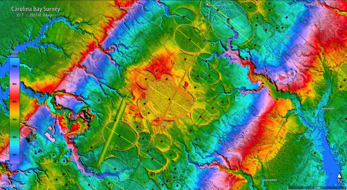

The thing that's missing so far from all of those simulations of air bursts is what happens to the ground. We don't see any material movement at all of the target surfaces in those simulations. The old way of looking at one of those things was to think of it as a point explosion high in the atmosphere. And it's still popular in the press to pretend the atmosphere dissipates the blast. It doesn't. Using super computers has allowed them to retain the downward momentum. So we can see the impact vortice hit the ground as a supersonic blast of ionized impact plasma hotter than the surface of the sun. It would be naive to a fault to think such energies can be dissipated in the atmosphere without significant planetary scarring, or ablative geomorphology. Those airburst impact simulations need to go a little further and consider the planetary scarring of a multiple airburst. None of them considers what happens in a stream of high velocity particles, and fragments, when stuff is falling into the already superheated impact plasma of fragments which have already hit. And unless someone can come up with another suspect, and a better astronomical model of the YD impacts, the Taurid Progenitor was the Younger Dryas comet. And it was already fragmented into just such a stream of debris long before it hit. Our problem here, is that good simulations that properly consider the motions, and conditions, of all of the blast effected materials, and thus the actual planetary scarring of such an event, might reveal some profound, and frightening, geomorphological truths folks are still afraid to know. But if, and when, those new, and improved, simulations are compared to actual Hi resolution images of the ground, it will change the NEO threat assesement in a very big way.
Moon to Earth: New LRO Lunar Crater Analysis has potential to revise impact frequency for Terrafirma
14 archived comments · Oldest first
Visit the article and join the conversation →A picture is worth a thousand words, a movie is priceless:
I love that simulation. Here's a 3.8 hi-res image map of what one of those things does to the ground. http://dl.dropbox.com/u/2268163/Mountain%20Flows.pdf Note the ejecta curtain. The deep V shaped excavations in the central uplift are the signature of the upwards flow at the center of the post impact vortice.
The question I might ask is there going to be any updates on the expected frequency of impacts here on Earth because of this new work, and to a lesser extent the small impact crater in Egypt (next post)? I hope so, as the NASA estimates are proving to be woefully inadequate. Also, I see that there is no mention of comets per se (or airburst events, as Dennis Cox mentions). This suggests to me that the scientists doing this work are still not completely up to speed, at least as I see it anyhow. Also, it is spelled Tunguska George.
You guys arn't too hip to Web 2.0 are ya?;) Rod, the spelling of the video name is done by the person posting the video to YouTube, not be me, I just "embedded" someone else video in my blog. Dennis, your dropbox didn't work here for me here or the other place you posted and linked to it from the Tusk. It may well work for others, and may be function of our firewall. However, a foolproof way to achieve the same result, sharing a document with others on blogs, etc., is Scribd. Which I know you have noted on the Tusk. You can load up any document you want to my Tusk account just by clicking the the Cosmic Tusk Scribd box on at the top left of the my blog, and then clicking "UPLOAD" at the top of the next page you see on Scribd. The benefits are then two-fold, it will always be available to Tusk readers and the rest of the world in the future, and you can share the link (or better the "embed" window) on your comments here or elsewhere. I would very much appreciate you giving this a shot, Dennis. If you guys would get accustomed to it -- uploading docs of interest to Tusk on Scribd, no sign-in needed -- it would be wonderful new avenue to share a lot of info effortlessly and professionally. Please give it a try guys! Let me know if you have any problems.
Actually Rod, the proper spelling of that word should be done with Cyrillic. since the Cyrillic alphabet is even more phonetic than ours, every thing is spelled exactly as it sounds. We don't have enough characters. 26 compared to 40. So even if you leave a word in its original slavic language, without translating it, and you simply try spell it with our character set, it will loose something. Under the principle that whatever works is valid, either spelling would probably be correct.
P.S. I'll put that thing on scribed too. But that link does work. It's an image map I made at a little better than 1 meter per pixel. It's just a big 3.8 meg file, and takes a while to load. The image is on a PDF. And it has enough resolution to zoom in 800% without getting fuzzy. If you'd rather see image maps like that in a different format, like a JPEG, it wouldn't be a problem.
Hmmm it's there now. It's titled Mountain Flows. And it's a PDF but it's blurry in that format. I'll upload the Hi-res JPEG image without the PDF shell to scribed, and see how that works.
Oh I am sorry George. I guess I should have known better than to think you were spelling Tunguska that way. Yes Dennis, out of respect for the Russians we should actually know tunguska by its Cryllic spelling.
Microsoft's Photsynth to the rescue. The image can be seen here: http://craterhunter.wordpress.com/the-planetary-scaring-of-the-younger-dryas-impact-event/a-thermal-airburst-impact-structure/ Click on the image of the mountain to see a 3d Potosynth of the structure.
Hello Yes, it is possible that representations of prehistoric and current super computers can represent the same dynamic phenomenon. Apparently, the prehistoric events were fairly frequent. Perhaps, scientists still have not properly investigated these pictures. And while I do not have simulators, some geometric details in the formation of these marks can be seen on the following sites: http://sites.google.com/site/cosmopier/impact-craters/holocene-palaeolagoons http://sites.google.com/site/cosmopier/impact-craters/palaeolagoon-geometry regards pierson
Hello folks, Dennis This is for You. On Mars, in the Sinai Planunm there is a twin structure you are investigating on Earth. It is about 30 km long. See on Google Earth, at: -14.535971, -81.816802. http://sites.google.com/site/cosmopier/impact-craters regards pierson
Thanks Pierson, From ‘Missing in action? Evaluating the putative absence of impacts by large impacts by large asteroids, and comets during the Quaternary period’. –W. Bruce Masse et al, 2007, we read, "Our understanding of the recent impact record may be inhibited by the necessarily conservative practice of not validating an impact structure unless it exhibits a full suite of impact hallmarks such as uplifted concentric rings, shocked breccias and quartz, and glass and other impact melts." I don’t want to be too critical here. The paper is excellent. But I would change that one line that reads, “may be inhibited by the necessarily conservative practice”. It should be amended to read “Is inhibited by the overly conservative practice”. A case in point is the Tunguska blast of 1908. The only officially recognized large impact event, indeed, the most powerful non-terrestrial explosion, in all of recorded history, was an airburst event that did not produce a crater. And, in spite of it’s obviously ET origin, the blast effected materials of that event do not qualify as an impact structure according to that “full suite of impact markers”. In fact the event didn’t display any of the planetary scarring expected by standard impact theory. And there is a significant, and growing body of compelling evidence that tells us the only thing rare about the Tunguska object is that it arrived alone. A large cloud, or stream of such air bursting fragments is far more likely. That "Full suite of markers" is nowhere near full, or accurate. And since it naively expects only one kind of single bolide event, it is effectively useless. In Google Earth take a look at 28.657070, –104.127108 There, you’ll find a 5.5 km by 12.73 km oval structure, where something hit from the southeast. The ejecta splash on its downrange end is a bit welded, and ablated, because the impact storm wasn’t through when it hit. But the planar fracturing of the rocks in the central uplift doesn’t leave much doubt what happened there. Oval craters are rare. And it doesn’t jibe with that “Full suite of impact markers” though. So we aren’t allowed to think of it as an impact structure. Imagine along with me here. Let’s do a little thought experiment. That oval can give us the the angle, and direction of impact. So we get approximately 30 degrees, and coming from the southeast. If we work from the postulate that those are some of the blast effected materials of the Taurid Progenitor, then we should be able to line that path up with the orbital path of one of the debris streams of the Taurid Complex. And in fact, we can. (There are many landforms in the region which confirm this directionality.) We may not be able to pin down the exact year, or day. But we can pin it to the daytime Taurids, so we know the season. And we can know that it was early afternoon local time. But if that Southeast to Northwest trend is the signature direction of the event that produced the blast effected materials in Mexico, and the American Southwest then there was more than one impact storm. Because a whole lot of something beat hell out of the Pleistocene/Holocene sediments of the Red Rock River valley of Southwest Montana. And there, they came from the southwest, instead of the southeast. Again in Google Earth see, 44.642389, –112.076805 You can also find the image map in the Tusk’s document vault, in a PDF file called Southwest Montana. Check out that whole valley closely. Those oval craters aren’t allowed to be thought of as impact structures either. But Glacial Lake Missoula, and its ice dam on the Clark Fork River, in northern Idaho were just downrange. Wanna bet we’re looking at the trigger for Harlan Bretz’s mega-flood?
P.S. We have many images of heavilly fragmented comets. It's an ongoing thing. They enter the inner solar system, they breakup and go away. Others fall in close to the sun with us to continue the dance, and break up as well. All it would take is one cloud, or stream, of debris from a fragmenting comet in an Earth crossing orbit like SW-3, or Comet Linear to plop down an impact shower of a thousand fairly large impacts in a few minutes. And your comfortable, and naive estimates, based on steady, and uniform, impact rates, are shot to hell. It is pretty clear that thinking we can estimate the age of a planetary surface by counting the number of craters we see is absurd.