
Some scientific controversies require satellites, laboratories, expeditions, and million-dollar equipment.
Others require a camera, a GPS unit, a range pole and free weekend.
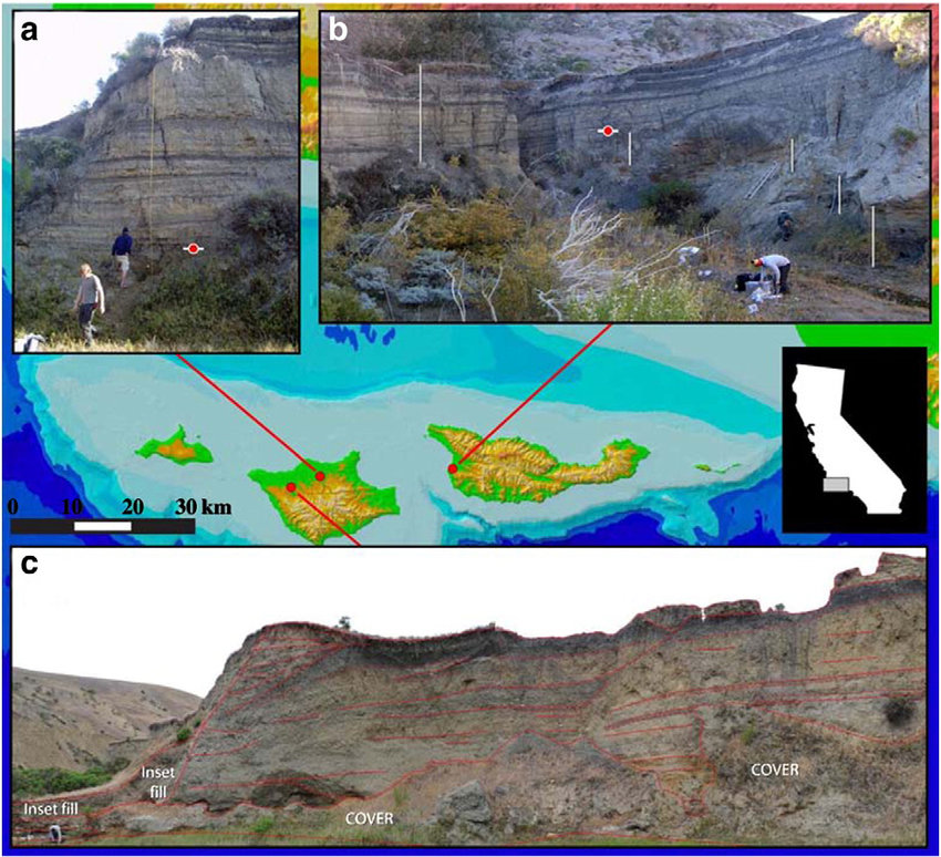
The Arlington Canyon exposure on Santa Rosa Island belongs in the second category.
For years, this remote canyon in Channel Islands National Park has occupied a peculiar place in the Younger Dryas impact debate. CRG-associated publications have identified a dark, organic-rich layer there as the Younger Dryas Boundary, associated with reported proxies including nanodiamonds, carbon spherules, soot, charcoal, microspherules, and a platinum anomaly.
But critics have pointed to other Santa Rosa Island exposures showing multiple dark, “black-mat-like” layers of various ages. Their point is simple enough: a dark band in Channel Islands stratigraphy is not automatically a Younger Dryas impact layer. It could be a floodplain deposit, a paleosol, a wetland interval, a charcoal-rich horizon, or some other organic layer.
Fair enough. That is not the end of the Arlington Canyon story. It is the beginning of the obvious next step.
John Johnson of the Santa Barbara Museum of Natural History put the issue plainly:
“There are black layers visible in the stream-cut banks in many canyons on Santa Rosa Island, but they don’t all date to the Younger Dryas.”
Exactly.
That statement does not refute Arlington Canyon as evidence for the most important thing that ever happened. It explains why Arlington Canyon deserves better public documentation.
Nobody serious needs the straw man that every dark layer on Santa Rosa Island is a Younger Dryas impact layer. The real question is whether the specific Arlington Canyon layer identified in the CRG literature can be cleanly compared with other dark layers on the island.
Are they at the same elevation? The same stratigraphic position? The same depositional setting? The same age? Or is the Arlington Canyon layer distinctive?
Those questions are answered with photographs, coordinates, elevations, measured sections, and dates.
This is the part that should be easy.
Santa Rosa Island is federal land. Arlington Canyon is a physical place.
And Santa Rosa Island is not just any island. It is mammoth country. The Channel Islands pygmy mammoth story is one of the most fascinating late-Pleistocene stories in North America: Columbian mammoths reaching the ancient island landmass during lower sea levels, becoming isolated, and eventually shrinking into the remarkable dwarf mammoths of Santarosae.
Readers of the Tusk know mammoths are not a decorative Ice Age mascot here. They have always been near the center of my interest in the Younger Dryas problem: extinction, black mats, fire, climate shock, human survival, and possible late-Pleistocene catastrophe. The pygmy mammoth story has fascinated me for years, and I even own a petite mammoth tusk, a photo of which I will include here.
That is why Santa Rosa Island matters to me beyond this one black layer. When a place contains famous pygmy mammoths, terminal-Pleistocene archaeology, disputed black mats, and a claimed Younger Dryas Boundary horizon, it deserves more than secondhand argument. It deserves fresh eyes, fresh photographs, and a careful return to the actual dirt.

Go to Arlington Canyon. Photograph the exposure properly. Shoot the canyon wall. Shoot the dark layer close-up. Include a scale, color card, north arrow, and range pole. Record the coordinates, the elevation of the stream bed, the base of the exposure, the bottom and top of the dark layer, and the surrounding landform.
Then do the same for the Santa Rosa Island exposures showing multiple black-mat-like layers.
This is not asking federal scientists to endorse the Younger Dryas impact hypothesis. It is asking them to document a famous locality on federal land.
If the Arlington layer is one of many dark floodplain or paleosol horizons, good documentation will make that clearer. If it is unusual, good documentation will make that clearer too.
Either way, everyone wins except the fog.
Please go photograph it. Please measure it properly. Please publish the results.
Selected References
The Arlington Canyon/Santa Rosa Island question sits at the intersection of Younger Dryas impact claims, black-mat stratigraphy, Channel Islands fire history, pygmy mammoths, and the island’s unusual modern land-use history. These are the papers and sources most directly relevant to that discussion.
CRG and Younger Dryas Boundary Papers
- CRG Firestone, R. B., West, A., Kennett, J. P., Becker, L., Bunch, T. E., Revay, Z. S., Schultz, P. H., Belgya, T., Kennett, D. J., Erlandson, J. M., Dickenson, O. J., Goodyear, A. C., Harris, R. S., Howard, G. A., Kloosterman, J. B., Lechler, P., Mayewski, P. A., Montgomery, J., Poreda, R., Darrah, T., Que Hee, S. S., Smith, A. R., Stich, A., Topping, W., Wittke, J. H., and Wolbach, W. S. 2007. “Evidence for an extraterrestrial impact 12,900 years ago that contributed to the megafaunal extinctions and the Younger Dryas cooling.” Proceedings of the National Academy of Sciences 104(41):16016–16021. DOI
- CRG Kennett, D. J., Kennett, J. P., West, G. J., Erlandson, J. M., Johnson, J. R., Hendy, I. L., West, A., Culleton, B. J., Jones, T. L., and Stafford, T. W. Jr. 2008. “Wildfire and abrupt ecosystem disruption on California’s Northern Channel Islands at the Ållerød–Younger Dryas boundary (13.0–12.9 ka).” Quaternary Science Reviews 27(27–28):2530–2545. DOI
- CRG Kennett, D. J., Kennett, J. P., West, A., Mercer, C., Que Hee, S. S., Bement, L., Bunch, T. E., Sellers, M., and Wolbach, W. S. 2009. “Nanodiamonds in the Younger Dryas boundary sediment layer.” Science 323(5910):94. DOI
- CRG Kennett, D. J., Kennett, J. P., West, A., West, G. J., Bunch, T. E., Culleton, B. J., Erlandson, J. M., Que Hee, S. S., Johnson, J. R., Mercer, C., Shen, F., Sellers, M., Stafford, T. W. Jr., Stich, A., Weaver, J. C., Wittke, J. H., and Wolbach, W. S. 2009. “Shock-synthesized hexagonal diamonds in Younger Dryas boundary sediments.” Proceedings of the National Academy of Sciences 106(31):12623–12628. DOI
- CRG Moore, C. R., West, A., LeCompte, M. A., Brooks, M. J., Daniel, I. R. Jr., Goodyear, A. C., Ferguson, T. A., Ivester, A. H., Feathers, J. K., Kennett, J. P., Tankersley, K. B., Adedeji, A. V., and Bunch, T. E. 2017. “Widespread platinum anomaly documented at the Younger Dryas onset in North American sedimentary sequences.” Scientific Reports 7:44031. DOI
- CRG Kennett, J. P., LeCompte, M. A., Moore, C. R., Kletetschka, G., Johnson, J. R., Wolbach, W. S., et al. 2025. “RETRACTED: Shocked quartz at the Younger Dryas onset (12.8 ka) supports cosmic airbursts/impacts contributing to North American megafaunal extinctions and collapse of the Clovis technocomplex.” PLOS One 20(9):e0319840. DOI
- Retraction The PLOS One Editors. 2026. “Retraction: Shocked quartz at the Younger Dryas onset (12.8 ka) supports cosmic airbursts/impacts contributing to North American megafaunal extinctions and collapse of the Clovis technocomplex.” PLOS One 21(2):e0342620. DOI
Pinter, Arlington Canyon, Black Mats, and Critical/Comparative Papers
- Critique Pinter, N., Scott, A. C., Daulton, T. L., Podoll, A., Koeberl, C., Anderson, R. S., and Ishman, S. E. 2011. “The Younger Dryas impact hypothesis: A requiem.” Earth-Science Reviews 106:247–264. DOI
- Critique Scott, A. C., Pinter, N., Collinson, M. E., Hardiman, M., Anderson, R. S., Brain, A. P. R., Smith, S. Y., Marone, F., and Stampanoni, M. 2010. “Fungus, not comet or catastrophe, accounts for carbonaceous spherules in the Younger Dryas ‘impact layer.’” Geophysical Research Letters 37:L14302. DOI
- Critique Scott, A. C., Hardiman, M., Pinter, N., Anderson, R. S., Daulton, T. L., Ejarque, A., Finch, P., and Carter-Champion, A. 2017. “Interpreting palaeofire evidence from fluvial sediments: a case study from Santa Rosa Island, California, with implications for the Younger Dryas Impact Hypothesis.” Journal of Quaternary Science 32(1):35–47. DOI
- Field context Schumann, R. R., and Pigati, J. S. 2019. “Fluvial sedimentary history of Arlington Canyon, Channel Islands National Park, California.” Journal of Quaternary Science 34(7):499–508. DOI
- Black mats Haynes, C. Vance Jr. 2008. “Younger Dryas ‘black mats’ and the Rancholabrean termination in North America.” Proceedings of the National Academy of Sciences 105(18):6520–6525. DOI
- Critique Daulton, T. L., Amari, S., Scott, A. C., Hardiman, M., Pinter, N., and Anderson, R. S. 2017. “Comprehensive analysis of nanodiamond evidence relating to the Younger Dryas Impact Hypothesis.” Journal of Quaternary Science 32(1):7–34. DOI
- California context Jones, T. L., and Kennett, D. J. 2012. “A Land Impacted? The Younger Dryas Boundary Event in California.” In Contemporary Issues in California Archaeology, edited by Terry L. Jones and Jennifer E. Perry, 37–48. Left Coast Press/Routledge.
Santa Rosa Island, Fire History, and Pygmy Mammoth Context
- Mammoths Agenbroad, L. D., Johnson, J. R., Morris, D., and Stafford, T. W. Jr. 2005. “Mammoths and humans as late Pleistocene contemporaries on Santa Rosa Island.” In Proceedings of the Sixth California Islands Symposium, edited by D. K. Garcelon and C. A. Schwemm, 3–7. Institute for Wildlife Studies. PDF
- Mammoths Muhs, D. R., Simmons, K. R., Groves, L. T., McGeehin, J. P., Schumann, R. R., and Agenbroad, L. D. 2015. “Late Quaternary sea-level history and the antiquity of mammoths (Mammuthus exilis and Mammuthus columbi), Channel Islands National Park, California, USA.” Quaternary Research 83(3):502–521. DOI
- Mammoths Hannold, C. D., Wang, Y., Wang, X., Dunn, R., and Hoffman, J. 2026. “Diets and environments of late Pleistocene pygmy and Columbian mammoths: Isotopic evidence from Southern California.” PLOS One 21(1):e0338674. DOI
- Mammoths Semprebon, G. M., Rivals, F., Fahlke, J. M., Sanders, W. J., Lister, A. M., and Göhlich, U. B. 2016. “Dietary reconstruction of pygmy mammoths from Santa Rosa Island of California.” Quaternary International 406:123–136. DOI
- Fire history Rick, T. C., Wah, J. S., Erlandson, J. M., and Braje, T. J. 2012. “Re-evaluating the origins of late Pleistocene fire areas on Santa Rosa Island, California, USA.” Quaternary Research 78(2):353–359. DOI
- Fire history Hardiman, M., Scott, A. C., Anderson, R. S., and Pinter, N. 2016. “Fire history on the California Channel Islands spanning human arrival in the Americas.” Philosophical Transactions of the Royal Society B 371:20150167. DOI
Santa Rosa Island Historical and Land-Use Context
- Island history Chawkins, Steve. 2011. “Family reluctantly gives up its hold on Santa Rosa Island.” Los Angeles Times, November 28, 2011. Background on the Vail & Vickers era, the island’s ranching history, the transfer into Channel Islands National Park, and the end of the family’s active role on Santa Rosa Island. Article