

Isn’t it astonishing that all these secrets have been preserved for so many years just so we could discover them!! — Wilbur Wright, June, 1903
No one has yet invented an explanation which will fully account for all the facts observed – Douglas Johnson, regarding Carolina bays, 1942
The Geological Society of America has invited Tusk friend Michael Davias to present at this year’s regional gathering in Charlotte, November 4 -7, 2012. The GSA should be faintly commended. As readers know, Mike is a relentless seeker of the truth behind Carolina bay formation and has concluded without prejudice using groundbreaking LiDAR that all bays have a simultaneously origin. That’s pretty radical stuff for the uniformatarian rockheads and academics of the Society. But fortunately, our pet theory has such a long and distinguished pedigree that it calls for periodic re-visitation by geological salons — even if assumed false. It seems GSA doesn’t mind lighting a little fire now and then so long as it is promptly stomped out.
Unfortunately, however, we cannot expect an equal opportunity for each thesis to be presented in the Queen City. The federal “Wind-Wave” scientists from the Savannah River Archeological Research Program are invited to speak — in the Big Hall — while Mike kicks sand in the poster room. This is a shame. Davias gives an excellent talk and was provided oral opportunities in the past by GSA. This time he got bumped — despite his new work.
That said, I was excited to see the wind-wave abstract and was hoping for a direct response to Davias’ previous appearances at GSA meetings. But (according to the abstract) not only is no new data being provided, the authors seem only to make an exclamatory and unelaborated reference to the ancient work of Ray Kaczorowski.
Bay geeks will recall that 1970’s Gamecock grad student Kaczorowski introduced a box of sand to a fan and blew faintly elliptical shapes onto the flat surface. No bays within bays, no bays interrupting and obliterating adjacent bays, no bays merging with other bays leaving no sign of a joined rim, no grand variation in scale as seen in nature — just kicked up, ugly, non-bay, roughly ovoid shapes. (What did he expect, squares?)
The true marvel of the bays — their sublime symmetry and inexplicable interactions — is entirely unaddressed by Kaczorowski and his modern acolytes. As I have pointed out over the last three decades, critics of a sudden and simultaneous formation do not admit what is obvious to the rest of us — these are not simply windblown ponds. There is clearly something else going on.
Lakes do not appear fully formed on narrow ridges; lakes blown into ellipses do not later appear oriented if formed in multiple generations intervened by countless eons — with no ability to distinguish the older generation from the younger; lakes do not endure millennia of windblown waves lapping at their shores with no lacustrine markers later in the sand.
No, windblown ponds on cold, flat, plains look like the aligned lakes of the Alaskan North Slope, and nobody confuses those features with bays — but Kacrowski and the wind-wave team.
I recognize the principle author of the abstract is Chris Moore, who will presumably be giving the talk in Charlotte. I have never met Chris in person but have corresponded with him through the years and know him as an open-minded investigator. In fact, I am certain he entertains the wider hypothesis of cataclysm at 10,000 BC. But Chris is clearly not compelled by evidence that bays were cosmically induced at that point.
Davias and Moore agree here. Mike’s analysis has yielded evidence that the bays must necessarily pre-date the 10,000 BC period — by >100K years. Make sure to note that in your review of his abstract, and perhaps I will post some explanatory material from Mike in that regard.
UPDATE: Here is Mike’s new work that dates the bays to >130KA.
An earlier presentation from Mike:
https://cosmictusk.com/wp-content/uploads/4-6_Davias_Notes_HQ.pdf
CAROLINA BAY FORMATION AND EVOLUTION: KACZOROWSKI WAS RIGHT! |
||
| MOORE, Christopher R., Savannah River Archaeological Research Program, South Carolina Institute of Archaeology and Anthropology,USC, PO Box 400, New Ellenton, SC 29809, [email protected], BROOKS, Mark J., Savannah River Archaeological Research Program, South Carolina Institute of Archaeology and Anthropology, USC, PO Box 400, New Ellenton, SC 29809, IVESTER, Andrew, Department of Geosciences, University of West Georgia, 1601 Maple Street, Carrollton, GA 30118, FERGUSON, Terry A., Wofford College, 429 N Church St, Spartanburg, SC 29303-3663, and FEATHERS, James K., TL Dating Laboratory, Department of Anthropology, University of Washington, Seattle, WA 98195Carolina bays are oriented, shallow upland ponds occurring on the Atlantic Coastal Plain from New Jersey to North Florida. Historically, Carolina bays have received attention from those speculating on a catastrophic emplacement through cometary, meteoric, or airburst impacts. Recently, it has even been speculated that bays formed from steam outgassing within superheated distal ejecta from an impact over the Great Lakes region. In this scenario, Quaternary-aged cover sands along the eastern seaboard, including “enigmatic” sand ridge scarps (e.g., Goldsboro Scarp) and Carolina bays, are purported to be causally linked to a catastrophic impact. Carolina bay shape, orientation, and sand rims are all used as evidence for an alignment with an impact crater not observed and not known to exist. Other researchers have posited that bays are linked with the purported Younger Dryas comet impact/airburst at ca. 12.9 ka, whereby bay formation was through aerial air-bursts or through a rain of distal impact ejectato form oblique craters.While these claims persist, our data indicate that Carolina bay origin and evolution are much better explained through more mundane, uniformitarian processes. The evidence gathered from Carolina bays in South Carolina and beyond demonstrate bay genesis as oriented lakes and formation through lacustrine processes of wind on shallow ponded water. Ray Kaczorowski’s wind table modeling in 1977 revealed quite clearly how unidirectional winds on pondedwaterproduce subaqueous circulation cells that shape and orient the bays, while constructing their sand rims as high-energy shoreline features.More recent work, including GPR, granulometry, OSL dating, and evidence from examination of LiDAR data, reveals that bays reflect long-term, pervasive and evolving environmental and climatological factors over millennia, not sudden or catastrophic events. Thus, a catastrophic origin is neither supported by geological data, nor needed to explain features we attribute to Carolina bays; Carolina bays are neither enigmatic, nor mysterious, but rather are relatively well understood oriented lakes. While nuances of bay formation through lacustrineshoreprocesses remain to be resolved, the fundamental concepts are well understood and have been for some time. Kaczorowski was right! | ||
| 2012 GSA Annual Meeting in Charlotte (4–7 November 2012) General Information for this Meeting |
||
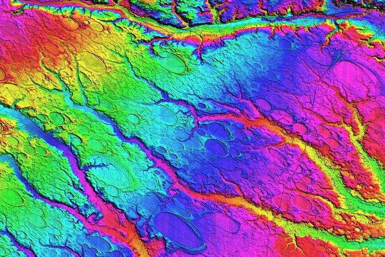
![]()
This LiDARelevation image shows the progression left to right (west to East) of the Holocene floodplain and current channel of the Cape Fear River, the Wando Terrace, and the Socastee Terrace. The total lack of bays on the extensive sandy surface of the Wando documents that no bays were created over the past 130K+ years. — Mike Davias, August, 2012
https://cosmictusk.com/wp-content/uploads/Davias_GSA2012_28-14.pdf
| 2012 GSA Annual Meeting in Charlotte (4–7 November 2012) | |
| Paper No. 28-14 | |
| Presentation Time: 9:00 AM-6:30 PM | ||
WHERE THE BAYS ARE: A TEMPORAL TALE OF CAROLINA BAY GEOMORPHOLOGY AS TOLD IN LIDAR BY THE WANDO AND SOCASTEE TERRACES |
||
| DAVIAS, Michael, Stamford, CT 06907, [email protected] years after aerial photography revealed thousands of aligned oval depressions on the USA’s Atlantic Coastal Plain, the geomorphology and ages of these “Carolina bays” remain enigmatic. Here, high-resolution LiDAR-derived elevation maps are used to examine Carolina bay landform distribution on terraces in the Cape Fear River Valley of North Carolina, in an attempt to identify and constrain their temporal distribution, which is of import to the gradualist vs. cosmic impact debate. The gradualist theory holds that bayswerecreated episodically by katabatic winds during glacial periods, while an impact event would create all bays simultaneously.The southeast flowing Cape Fear River has been incising its southwestern channel wall for over 2 million years, migrating up to 35 km laterally as its bed was tilted by the persistent tectonic uplift of the Cape Fear Arch. When combined with general regional uplift, a series of expansive and distinct unpaired fluvial terraces have been preserved, each created in turn during interglacial high stands of the Atlantic. This tableau provides a unique temporal index to the evolution of the coastal plain. Adjacent to the current-era flood plain is the Wando Terrace, considered by others to have formed during marine isotope stage (MIS) 5 interglacial ~80ka–135ka, based on uranium-series and amino acid methods. Continuing towards the Arch, the Socastee Terrace is considered to represent MIS 7 ~186ka–245ka, the interglacialprecedingthe Illinoian glaciation.LiDAR elevation maps reveal a Socastee terrace populated with well-defined Carolina bays. Likewise, the successively older Penholoway, Waccamaw and Bear Bluff Terraces are rich in bays. In striking contrast, the LiDAR shows the Wando Terrace to be indisputably devoid of Carolina bay landforms. The absence of bays on the MIS 5 surface suggests a minimum date constraint for bay formation of ~135ka. Younger dates identified in the literature may depict reworking, not initial bay genesis. This finding is problematic for the gradualist theory, as the Wando surface should have offered a viable nursery during the last Glacial Maximum (MIS 2). The temporal data implies that if Carolina bays were created during a cataclysmic event, it must have occurred before MIS 5 and after MIS 7, thus during MIS 6, the Illinoian glaciation ~135ka–186ka. | ||
| 2012 GSA Annual Meeting in Charlotte (4–7 November 2012) General Information for this Meeting |
||
In the paper, Very high-temperature impact melt products.. there is a report (by George Howard) of using a hand auger to extract a core from the CB rim that contains a black mat section. So apparently the bay rim is younger than the black mat. This contradicts the > 130K year age for the CBs based on the age of the Wando terrace. Could not the Wando river have eroded all of the bays on the terrace? The core seems to confirm deposition of the CB sand immediately post YDB black mat formation.
Ed, no I don’t assume that at all, it’s just from his coring with a hand auger in a CBay rim and hitting the YDB layer just below, that it looks that way. This is in the appendix to the PNAS “Very High-Temperature Impact Melt Products . . ,”
SUPPORTING INFORMATION (download PDF):
http://www.pnas.org/lookup/suppl/
doi:10.1073/pnas.1204453109/-/DCSupplemental
Hello to all
Is it possible that these structures if End-Pleistocene age, may have them been embanked immediately by great floods of melting glaciers?
regards
pierson
Herman:
The age is certainly in question, no doubt. Please note that the Wando terrace was surfaced by the Cape Fear River when it became a flood plain after the Illinoian Glaciation terminated 135ka and the sea level rose to as much as 10m above today’s. It is covered with many datable deposits which set its age as 80ka to 130ka. When the sea level again dropped going into the Wisconsin ice age, the Cape Fear abandoned the Wando Terrace (as it previously did from the Socastee, Penholoway, Waccamaw and Bear Bluff Terraces, carving deeper beneath its current flood plain position. I agree that the river may have (and likely did) “remove” bays originally resident across that expanse, but the point remains that none were created since. Certainly none 12ka. There are none on the Holocene terrace surfaces, either (which cover the expansive flood plain closer to the mouth of the river near Wilmington), but no surprise there.
If the bays were created 130Ka+, we should all expect that the top 1/2 meter of sand and soil would have been remodeled, stratified with new wind-blown sediment and reworked by soil formation episodically during warmer and wetter times.
The YDB debate hardly rests on the creation date of the Carolina bays!
– Michael
Thank you, Michael. I hope that your note clears up Hermann’s confusion.
As far as the Bays’ age goes, I noted that one paper cited here mentioned the presence of Clovis technology at one of them. That was prior to the HSIE.
The most siognificant point about the Bays is that the sand in them contains no fossils, while they are held together by what is most likely some kind of calcium derived cement. Something strange happened; what it was, I don’t know.
There is so much geologicqal work to be done with known HSIE features that I’ll leave the Bays for others. So far I have seen no ethnographic materials bearing on them.
For that matter, have you found any other mentions in the geological materials from the area of the ca. 1,000 BCE impact mega-tsunami, or of the smaller impact mega-tsunami ca. 580 CE?
As a graduate geographer in Colorado, I became curious about the many shallow, oval depressions on otherwise relatively level western plains; aka “Buffalo Wallows.”
My studies in landform evolution and employment with Shell Oil, researching deep earth gases, led me to believe the depressions were the result of soils inflated by deep earth gas emissions, initially forming low “hills.”
Naturally, as hills erode, coarser debris would collect around their bases and finer particles would be swept away. Later, when the rate of gaseous emissions decreased, these eroded hills would deflate into depressions with a ring of coarse debris around their borders.
Some of these depressions are a mile or more in diameter, while others are only a few acres in area. All seem to have an oval orientation in line with the direction of sands and gravels deposited by the erosion of nearby mountains.
Similar depressions have been reported in Kansas and Indiana as well as the Carolinas. In addition, secondary rings have been observed inside larger rings, indicating to me that increasing gaseous emissions created another hill which also eroded and formed a secondary depression within the first, when emission rates again declined.
I have seen gaseous expansions in the mud pots of Yellowstone, which resulted in depressions with raised borders, along with secondary expansions inside the first, ending with smaller depressions and raised borders inside the initial depressions. These appear much like the initial and secondary depressions which can be found across the USA and in Carolina Bays; on a larger scale.
My friends with similar views have recently drilled into a number of Carolina Bays and surrounding soils. They found gas emissions within the borders to be as much as 10 times the emission rate in soils outside the borders.
Now we are seeking a Carolina Bay that has yet to fully deflate, possibly appearing as a level area or low hill, with a beginning border of debris from surface erosion. If anyone knows of a possible example, please let me know. Charlie, [email protected].
Thanks, Charles!
Hi Charles,
I’ve collected a few hundred Google Earth images of those ‘Buffalo Wallows’ most of the ones I’ve imaged are in west Texas and eastern New Mexico. And i support of your theory that they are related to gaseous emissions, the highest concentrations of them can be found in, or near large oil, and gas fields.
Anyone know of any significant oil, or gas drilling/production among the CBs?
Dennis, if that is in support of gas emissions being correlated to oil or gas fields, we’d expect to find oil fields in the Carolinas.
It does not really explain the overlapping bays/wallows, not that I can see. Charles mentioned “secondary expansions inside the first”, but it is circular reasoning to use the term “expansions” when expansions are the supposition being considered. And what is meant by “inside the first”? Features” yes, “secondary expansions” assumes too much, as if the conclusion is already proven. Also, does it mean fully within or does it include overlaps?
Charles’ hypothesis does nothing to explain either the ellipticity or the alignments of the CBs, so we can put it with other ‘possibles’ for now. At the same time, subterranean causes do need more looking into. So far none of the wind/water/impact explanations can explain all the features, so subterranean is a viable area of inquiry.
Also, Charles, any leads on the Indiana wallows? That is awfully close to the Michigan ‘center’ toward which Davias’ work points.
Thanks Steve,
I was just making the point that if the ‘Buffalo Wallows’ are indeed related to gas emissions, as their apparent concentrations in and around oil and gas fields might seem to imply, and if they shared the same formation mechanism as the CBs, then there should be huge oil, and gas reserves beneath areas where there are a lot of Bays. Yet to the best of my knowledge, The Carolinas are in no danger of being overrun by folks drilling for oil, or gas.
I’ve been studying the ‘Buffalo Wallows’ in the southwest long enough to have collected individual images of more than a thousand of them. And frankly, I see no comparison or similarity to the form, or fractal distribution we see in the Bays. And I am extremely doubtful that they share the same formation mechanism.
It should be noted though, that while there are a number of interesting theories as to the exact formation mechanism of the BWs, they remain almost as enigmatic as the Bays.
Thanks, Dennis. For the info and your other thoughts, too. As we each collect facts about enigmas, we each assign varying validities to them, and we put those together in some form of hierarchy of evidence. Using that hierarchy, we do hear possible explanations that we do get “extremely doubtful” about.
I would not at all be surprised if the CBs do turn out to have a subterranean cause, though such an explanation would have some extra hoops to jump through. Davias’ LIDAR work on shapes and alignments will be tough on any potential explanation except something connected to an impact. Wind, water, gaseous expansions – none of them are capable of covering any of the alignment or shape evidence. Not in my book, anyway. Not that I am the most knowledgeable, though.
The wallows – is there any alignment to them at all? If so, can you point to that info?
No, there is no consistant alignment to them at all. There is also no consistent form to them like we see in the Bays. Most are round, some have double rings like a complex crater, and some in New Mexico are just too damn big to believably be simply the result of gas emmisions breaking the surface.
In the work I’ve read, I note that to date, no one has done anything to look in detail at the mix of isotopes found in them. So I’m still woundering about the exact chemistry.
I’ll put together a gallery of photos of them, and post it on dropbox.com over the next few days if anyone’s interested.
Buffalo Wallows are of interest to me also. We have some pretty good LiDAR of our project in Texas: http://www.restorationsystems.com/projects/katy-prairie-mitigation-bank-stream-wetland-credits-houston-texas/
The depressions are all over the place (as is gas) but I would enjoy seeing Mike Davias take shot at characterizing them over a large area in LiDAR.
OK I don’t have any time for this at all.
So you better highlight some BWallows and lemmie have a look….
Could be toroidal ball lightning!
TH
On the subject of “Buffalo Wallows” and other strange holes in the ground, there is no shortage of places that are cryin’ for a closer look. A few might be just plain old sinkholes. Many of them look to have been modified for water management purposes. But even those show an interesting halo.
Here’s a sample gallery. And it’s only the tip of the iceberg. Each image is directly from Google Earth. And the Latitude, and Longitude, is in the status bar at the bottom of the image.
https://www.dropbox.com/sh/kssdajhznc77c2g/lA6ofEWbfr