It’s a little lazy, but not unknown in blogging circles, to cut yourself some slack and repost old material for new readers. When poking around for an “Oldie but Goodie” to repost, I came across this number from 2012. I post again to inspire some interest from readers — perhaps one of many well credentialed readers — to take a serious look at this “coincidence.”
I have always been personally curious about the lack of documented evidence for a tsunami ever occurring on my home coast of North Carolina. Some of the largest undersea land slides on earth have been documented off our wonderful Outer Banks, and earthquakes are not completely unknown in the Carolinas. Both cause big waves — but none (zero) are acknowledged to have occured in the geological record.
Why is there not some sign of a big wave ever — just once — running up onto the flat and featureless Carolina coast in human times?
However, some very credible work has documented cosmically-induced tsunami in the New York and Hudson Valley region, not far away from NC in a regional sense. After re-reading some of the work of Dallas Abbott and others describing tsunami signatures in Long Island Sound and the Hudson Valley, I was googling about for anything else hinting at such a wave. I had looked before — but apparently prior to the 2007 publication of the article below.
ABSTRACT
We document here the threat of large scale destruction (collapse) of barrier islands based on the study of many cores taken along the Outer Banks and in Pamlico Sound, North Carolina. Around 1,100 cal yr BP, probably as the result of hurricane activity, portions of the southern Outer Banks must have collapsed to allow normal salinity waters to bathe southern Pamlico Sound for several hundred years. Such collapse could occur again during our current regime of global warming, rising sea level and increased tropical cyclone activity. The economic effect of barrier island break collapse on Outer Banks communities would be devastating.
Culver et al., 2007
[wonderplugin_pdf src=”https://cosmictusk.com/wp-content/uploads/north-carolina-tsunami.pdf”]
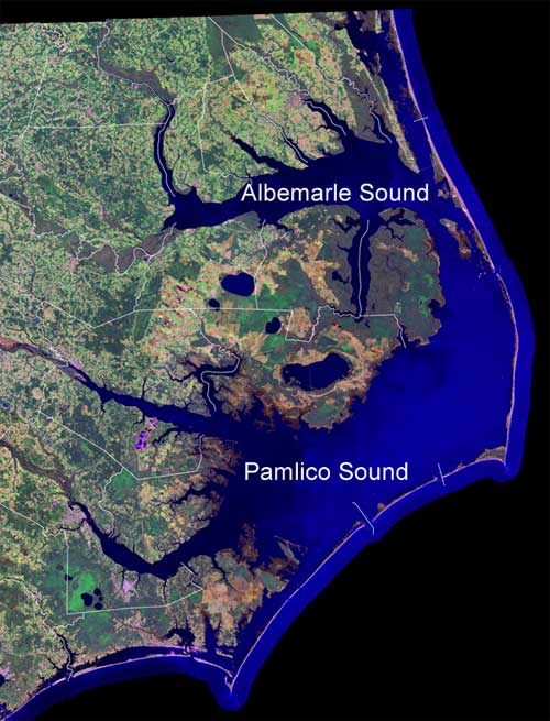
The authors describe a catastrophic inundation around 1000 AD of the Pamlico Sound, the 2000 square mile shallow estuary that defines North Carolina’s coast. Look closely at the seaboard of our proud state. The coast is characterized by long narrow barrier islands that embay the Pamlico Sound, an inland sea, as thought by Verrazano.
I knew work had been underway for years taking geological cores from under these Sounds, led by Stanley Riggs of ECU and the USGS. But I had not seen much of interest to the Tusk (though I have not paid terribly close attention).
In any case, when I read the papers, I found out the sediment cores of Pamlico Sound demonstrate the sound had been repeatedly — at least twice in the last 5000 years — inundated by seawater. Flooded so thoroughly by the sea that the former sound became open marine waters for hundreds of year before closing again.
The authors presume it was a hurricane or closely spaced hurricanes that caused the Pamlico Sound to become the sea again for 500 years.
“This paper reports on the intriguing sedimentary and micropaleontological record of several vibracores that indicates that the southern Outer Banks barrier islands underwent significant destruction, presumably as the result of a major hurricane or hurricanes, approximately 1,100 cal yr BP. Culver, et. al. 2007″
The Tusk thinks the authors are probably underestimating the potential for a cosmic tsunami. Dr. Abbott, an earth scientist as well, found evidence of Holocene tsunami’s on the eastern seaboard and concluded they were induced by rocks into the pond.
[https://cosmictusk.com/wp-content/uploads/Abbottetal_2010_Exotic_Grains_Bog_NY.pdf]
https://cosmictusk.com/wp-content/uploads/Abbottetal_2010_Exotic_Grains_Bog_NY.pdf
Culver et al., think differently and quickly dismiss tsunami (and surely cosmic tsunami) as a cause of the Pamlico inundation:
“Tsunami and hurricanes are potential causes of barrier island collapse. Unfortunately, foraminiferal signatures of tsunami are not yet sufficiently well defined (e.g., Hawkes et al., 2006). Major hurricanes (category 3 and greater) hit coastal North Carolina several times a century, but vibracore PS03, three adjacent cores, and more than 30 cores across the Hatteras Flats and through the modern barrier islands, indicate just one substantial collapse, several centuries in duration, since the barrier islands formed around 3,500 cal yr BP. A major hurricane, or a closely spaced series of major hurricanes, such as hit the Gulf Coast in 2004 and 2005, is the most likely [emphasis mine] proximal causal agent in this North Carolina coastal region that was dubbed, “Hurricane Alley.””
Culver, et. al. 2007
The authors kind of leave you hanging after the tsunami reference, huh?
Culver, et al. don’t rule out a tsunami, but rather claim their manner of testing for abundance and types of tiny sea creatures called “foraminifera” cannot — yet — define a tsunami. Fair enough, but it still leaves me wanting them to rule tsunami out on other grounds — which they do not.
Then things get more interesting — much more interesting. Looking for references to an Atlantic tsunami in 1000 AD, I remembered another Dallas Abbott paper which I posted last year to the Tusk. In the paper Abbott tentatively dates tsunami materials from a New York bog to several time periods. And she puts the most recent tsunamic material layer in New York within the same period as the Pamlico inundation, the first century of the second millennia.
[wonderplugin_pdf src=”https://cosmictusk.com/wp-content/uploads/Abbottetal_2010_Exotic_Grains_Bog_NY.pdf”]
Further corroboration is found in the English annals from September 28, 1014, where Middle Age historians note a “flood from the sea” in England.
See these references to the English tsunami from “Tsunami Chronology supporting Late Holocene Impacts”
“On 28th September 1014 widespread coastal flooding occurred in Britain [13]. William of Malmesbury in The History of the English Kings (vol. 1) states that «a tidal wave, of the sort which the Greeks call euripus and we ledo, grew to an astonishing size such as the memory of man cannot parallel, so as to submerge villages many miles inland and overwhelm and drown their inhabitants.[23].
For the same year, the Anglo-Saxon Chronicle states that «on the eve of St. Michael’s Day [28th September], came the great sea-flood, which spread wide over this land, and ran so far up as it never did before, overwhelming many towns, and an innumerable multitude of people» [16]. Some accounts suggest that this flood affected Kent, Sussex, Hampshire [11], and even as far west as Mount’s Bay in Cornwall, where the Bay was «inundated by a ‘mickle seaflood’ when many towns and people were drowned» [29]. Healy [15] describes organic deposits in Marazion Marsh, that lie behind a coastal barrier in Mount’s Bay, that is dated to no later than AD 980 and overlain by a sand layer, which could be a signature of the flood event. In North Wales, it has been suggested that recently described field evidence for tsunami impact may be related to this Celtic event [14]. The flood is also mentioned in the Chronicle of Quedlinburg Abbey (Saxony), where it states many people died as a result of the flood in The Netherlands, and it is remembered in a North American account by [17].”
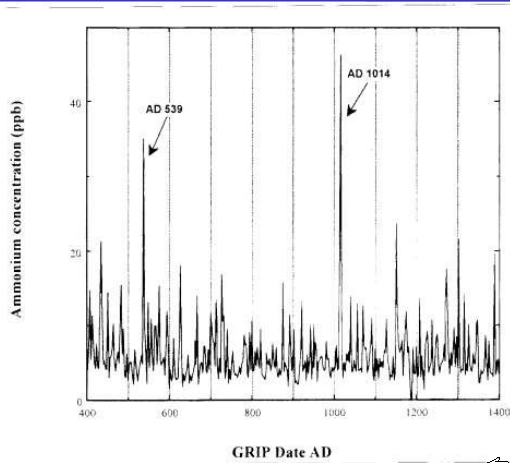
1014 AD saw the most intense spike of Ammonium in Greenland ice in 1000 years
From Abbott et al. 2010
Pretty interesting, huh?


